Draft Greater Norwich Local Plan – Part 1 The Strategy
SECTION 6 - APPENDICES
Appendix 1 Infrastructure requirements
This appendix provides additional detail to support policy 4 of this plan. It sets out infrastructure requirements to serve growth as identified in the Greater Norwich Local Plan Infrastructure Needs Report (GNLPINR). The GNLPINR and this appendix will be updated to inform the Publication (Regulation 19) version of the Greater Norwich Local Plan.
The infrastructure will be provided by a variety of organisations and funding sources. The requirements have been identified through ongoing and completed topic and organisation-based studies and strategies which inform both the GNLPINR and this plan.
Pedestrian and Cycling
Awaiting the findings of the Local Cycling and Walking Infrastructure plan (LCWIP), which is currently being developed.
Rail
Awaiting findings of the Norfolk Rail Prospectus, which is currently being reviewed.
Road
In addition to the schemes Highways England have committed to, further trunk road junction improvements may be required for future growth. The A47 Longwater Interchange and the following junctions will require further investigation:
- A47/A140 Ipswich Road
- A47/A146 Loddon Road
- Spinks Lane, Wymondham
- New Road, Acle
Water
Anglian Water's Water Recycling Long Term Plan plans for growth to 2045 through increased capacity at the following water recycling centres:
Acle; Aylsham; Belaugh; Long Stratton; Rackheath Springs – Wroxham; Sisland; Woodton; Whitlingham and Wymondham.
Energy
Substations requiring upgrades and/or the use of measures to off-set the need for reinforment (such as demand side responses and energy storage (batteries):
|
Substation (132/33kV) |
Affected development sites |
|
Sprowston Primary |
Beeston Park Home Farm Sprowston Land off Salhouse Road Land south of Green Lane East Land south of Green Lane West Land south of Salhouse Road Rackheath White House Farm |
|
Peachman Way Primary |
Broadland Gate Brook Farm Land east of Broadland Business Park Land north of Broadland Business Park |
|
Earlham Grid Local A/B |
Costessey GN Food Enterprise Park Longwater / Easton Norwich Research Park Three Score |
|
Cringleford Primary |
Cringleford Hethersett |
Broadband
A guide to Broadband for Norfolk Local Planning Authorities produced for the Norfolk Strategic Planning Framework sets out that superfast broadband coverage is rapidly improving, 92% of Norfolk's homes and businesses can now access superfast broadband, up from 42% in 2012 and initiatives, led by the County Council aim to make high-speed broadband available to more than 95% of Norfolk's premises by spring 2020. The report recommends that all residential developments over 10 dwellings and all employment developments will enable Fibre to the Premises (FTTP).
For schemes under these thresholds the Council's expectation is that provision for FTTP will be achieved, where practical.
Education
Norfolk County Council have six schools (three primary, one free school and two primary relocation and expansion) either in the process of being built or plans are in place for building over the next 2-3 years.
Other new schools are planned across the Greater Norwich area once housing and pupil numbers suggest that existing schools in the area are no longer able to accommodate local children. These currently include 10 new primary schools and one secondary school:
- Wymondham Silfield – 420 place primary school.
- Poringland – new school in response to considerable housing in the area – site search investigation being commissioned.
- Salhouse Road, Sprowston – site safeguarded for new 420 place school within new housing development.
- Hellesdon – new 420 place primary school within new development on former golf Club grounds.
- Beeston Park – sites for 2 x 420 place schools within proposed new housing development.
- Beeston Park – currently identified location for the new secondary school required to support housing growth in the area.
- Rackheath – 2 x 420 new primary phase schools.
- Land north and south of Smee Lane, Norwich – planned new 420 place primary school in response to growth.
- Long Stratton – new 420 place primary school building in response to strategic growth in the village.
There will be additional new schools and school expansions to provide for the new allocations made through this plan. For larger sites, these have been considered as part of site allocations e.g. the preferred option site for 1,400 homes at Taverham includes a primary school site.
Health Care Requirements
|
Type of need |
Existing Services |
Additional need resulting from growth |
|
Primary Care |
GPs (currently 68 surgeries, 43 of which are main surgeries and 25 branch surgeries), community pharmacists and optometrists. |
There are currently 2 options to increase capacity as required around the north and north-west of Norwich:
The selected option will be confirmed in the annual review in 2020. |
|
Hospital |
There is one acute hospital, the Norfolk and Norwich University Hospital NHS Foundation Trust (NNUH). Other services are delivered from several other locations. |
The NHS Long Term Plan and the STP Delivery Plan, currently in production, will address building capacity and facilities (including new rooms, theatres and beds, current estimated cost c. £36 million) and parking issues. |
|
Mental Health |
Norfolk and Suffolk NHS Foundation Trust (NSFT) provides a broad range of services across Greater Norwich, with Hellesdon Hospital and the Julian Hospital in Norwich the largest sites. |
In line with the shift to care in the community, the mental health trust is expected to shift services to wrap around primary care networks. Existing clinical and administrative provision at Hellesdon is not fit for purpose. This area of the site is going through a disposal process for housing. The NSFT's remaining accommodation in Norwich has constraints, including parking at the Julian Hospital. There is no spare capacity in primary care for mental health services in Diss and this may need to be reviewed. The above is included in the NSFT estates strategy review to be addressed as by the GNLP as and when appropriate. |
|
Community Services |
These are provided by Norfolk Community Health and Care NHS Trust at community hospital sites and health centres and include: • Inpatient specialist rehabilitation services; • Clinic services for outpatients; • Community nursing in patients' homes. |
Clinical rooms are required at: Norwich Community Hospital; NNUH; Thorpe and Wymondham Health Centres (estimated total cost c. £200,000). |
Police
Awaiting findings of the infrastructure work Norfolk Constabulary have commissioned NPS to produce.
Libraries
The Greater Norwich housing growth locations show an impact to the north east of the Norwich city boundary centred around Rackheath with an estimate of some 13,000+ dwellings. This has previously been identified as an area that will require additional library facilities due to the scale and size of the development. Therefore, based on an anticipated growth of 13,000 dwellings and an increased population of c26,000 people this would equate to 780 square metres of library space. We would anticipate, however, that this is over provision bearing in mind the location of other facilities in the locality and we suggest this is reduced to 390 square metres with an anticipated building cost of c £1millon.
Sports and Leisure
Awaiting findings of the Greater Norwich Sports Facilities Strategy, which is currently being reviewed.
Waste Management
Norfolk County Council has approved a capital programme for recycling centre improvements, including:
- Replacing the current Mile Cross Recycling Centre and relocating the site at Ketteringham to South Norwich;
- Replacing the Wymondham recycling centre and expanding the site at Morningthorpe;
- Extending the Strumpshaw Recycling Centre.
The capacity of new and extended sites will be designed to accommodate forecast growth. Funding for recycling centre improvements has been allocated by the County Council for the replacement sites for Mile Cross, Ketteringham and Wymondham and the extension of Strumpshaw and Morningthorpe. If required, contributions may be sought to deal with the cumulative impact of a series of both small and large developments.
Accessible
In the case of community facilities and services (such as healthcare), easy to travel to or use. With reference to buildings or public transport, easy to enter and use by all.
Active travel
Making journeys by physically active means, like walking or cycling. Active travel is promoted by Public Health England and by the National Planning Policy Framework through its focus on design which promotes health and well-being (paragraph 127 e)).
Affordable housing
Housing provided for sale or rent at prices below the current market rate, which people in housing need can afford. Affordable housing tenures are defined in Government guidance, as set out in Annex 2 of the National Planning Policy Framework.
Air Quality Management Area (AQMA)
A place where the National Air Quality Objectives are not being met. Once an AQMA has been declared the authority has to carry out further work to monitor the air quality in the area and identify what actions can be taken to improve it.
Allocated
Land which has been identified for a specific use in the current development plan.
Appropriate Assessment
Analysis of the impact of plans and strategies on areas of designated European environmental importance such as Special Protection Areas, Special Areas of Conservation and Ramsar sites.
A development plan document within the local plan that establishes a set of development proposals and policies for a specific area. In Greater Norwich there are current adopted area actions plans for the North East Growth Triangle, Long Stratton, and Wymondham.
Biodiversity
The variety of different types of plant and animal life in a region.
Biodiversity net gain
Refers to development having a positive impact on biodiversity, leaving it in a better state than before development occurred.
Brownfield land, brownfield site
Land or site that has been subject to previous development.
Brownfield Register
Brownfield land registers provide up-to-date information about sites that local authorities consider to be appropriate for residential development having regard to the relevant legislation.
Building for Life 12
A government-endorsed industry standard for well-designed homes and neighbourhoods. Local communities, local authorities and developers are encouraged to use it to guide discussions about creating good places to live. The National Planning Policy Framework encourages its use in local plans.
Built environment
The man-made surroundings that provide the setting for human activity, ranging in scale from personal shelter to neighbourhoods to large-scale civic surroundings.
Business use
Land use class covering light industry, offices, research and development.
Cambridge Norwich Tech Corridor
A public-private partnership spanning Norfolk, Suffolk and Cambridgeshire set up to deliver high-value economic and societal growth in clusters between Cambridge and Norwich within the technology/science sector.
City centre
The main commercial area of Norwich that is predominantly within the Inner Ring Road (A147). The exact boundary is shown on map 9 of the local plan.
Climate Change Mitigation
Actions taken to limit the magnitude or rate of global warming and its associated effects, usually involving a reduction in human emissions of greenhouse gases.
Commitments
Development proposals which already have planning permission or are allocated in adopted development plans.
Community facilities
Services that meet the day-to-day needs of a community such as village halls, post offices, doctors' and dentists' surgeries, play areas, recycling facilities, libraries and places of worship.
Community Infrastructure Levy (CIL)
A financial charge on new development introduced by the Planning Act 2008 as a tool for local authorities to help deliver infrastructure to support growth and development in their area.
Conservation area
Area of special historic and/or architectural interest which is designated by the local planning authority as being important to conserve and enhance. Special planning controls apply within these areas.
Core Bus Routes
A network of main bus routes where service frequency and bus priority will be enhanced.
County Wildlife Site (CWS)
Wildlife habitat identified and designated as being of local interest or importance by Norfolk County Council and the Norfolk Wildlife Trust, but which is not of enough national merit to be declared as a Site of Special Scientific Interest. A CWS does not benefit from statutory protection but does have some protection in the planning system.
Custom-build housing (see also self-build housing)
A form of self-build home that is, in some form, supported by a developer through a more hands-off approach than traditional self-build would entail.
Decentralised and renewable or low-carbon energy sources
Sources of energy that are renewable or low-carbon (or a combination of these) and locally based (on-site or near-site, but not remote off-site), usually on a relatively small scale. Decentralised energy is a broad term used to denote a diverse range of technologies, including micro-renewables, which can locally serve an individual building, development or wider community and includes heating and cooling energy.
Development
Defined in planning law as 'the carrying out of building, engineering, mining or other operations in, on, over, or under land, or the making of a material change of use of any building or land'.
Development Plan
A set of plans guiding future development in the area. The development plan consists of the locally prepared development plan documents, including Neighbourhood Plans approved at referendum.
Development Plan Document
Locally prepared document on a specific topic which forms part of the development plan and which subject to independent examination before adoption, also commonly referred to as DPDs.
District centre
A group of shops separate from the town centre containing at least one supermarket or superstore as well as other services. District centres provide for a catchment extending beyond the immediate locality.
Economic Strategy for Norfolk and Suffolk (ESNS)
A shared strategy between businesses, education providers, local councils and voluntary and community sector, which is led by New Anglia LEP outlining future growth across the region.
Employment use
Use primarily for industrial, warehousing, office or other business uses falling within classes B1, B2 and B8 of the use classes order.
Five-year housing land supply
A requirement by Government for local planning authorities to ensure that there is enough land available that is suitable, available and deliverable for housing development. The amount of land available should be enough to fulfil the housing requirement for the next five years.
Food Enterprise Park
46 acres of commercial development land with planning available for food related businesses near Easton and Honingham. A Local Development Order (LDO) is in place for part of the site.
Geodiversity
The variety of different types of geology, landforms, soils and physical processes in a region.
Greater Norwich City Deal
An agreement between Government and Greater Norwich, which provides the city and surrounding areas certain powers and freedoms to take responsibility for decisions that affect Greater Norwich. It is implemented by the Greater Norwich Growth Board (GNGB).
Greater Norwich Growth Board (GNGB)
A partnership between Broadland District Council, Norwich City Council, South Norfolk Council, Norfolk County Council and New Anglia Local Enterprise Partnership (LEP) to provide homes, jobs and infrastructure. It also provides strategic direction, monitoring and co-ordination of the Greater Norwich City Deal.
Greater Norwich Local Plan Infrastructure Report (GNLPIR)
A supporting document to the GNLP focusing on transport, utilities, education, health care, fire and rescue, community facilities, sport and leisure facilities, green infrastructure and waste management.
Green infrastructure
A network of multi-functional green space which delivers benefits to both the environment and the local community. Green infrastructure includes natural green spaces colonised by plants and animals and man-made managed green spaces such as areas used for outdoor sport and recreation including public and private open space. These spaces may include allotments, urban parks and designed historic landscapes as well as their many interconnections such as footpaths, cycleways, green corridors and waterways.
Greenfield land (or site)
Land which has not previously been built on, including land in use for agriculture or forestry. Greenfield land does not include residential garden land.
Growth Triangle
An area to the north-east of Norwich identified for major growth.
Habitat Regulations Assessment (HRA)
An HRA identifies any aspect of the emerging Local Plan that would have the potential to cause a likely significant effect on Natura 2000 sites or sites protected by European designations (Special Areas of Conservation, Special Protection Areas, Ramsar sites) either in isolation or cumulatively, and to identify appropriate avoidance and mitigation strategies where impacts are identified.
Health Impact Assessment
An assessment required for large sites and for any housing proposal with a significant amount of housing for the elderly to show how the health care infrastructure needs of the new development are provided for.
Heritage Asset
A building, monument, site, place, area or landscape with historic interest that provides a material record of history or meaning for a community. Heritage assets may be either 'designated' or 'non-designated' and have a degree of significance that merits consideration in planning decisions.
Historic environment
Aspects of the environment which result from the interactions between people and places through time.
A form of economic growth that aims to improve opportunities for everyone in the local community.
Index of Multiple Deprivation
A ward-level index made up from six indicators (income; employment; health deprivation and disability; education; skills and training; housing; and geographical access to services)
Infill development
Small-scale development filling a gap within an otherwise built up area.
Infrastructure
The network of services to which it is usual for most buildings or activities to be connected. Infrastructure includes physical services serving the development (e.g. gas, electricity and water supply; telephones, sewerage) and includes networks of roads, public transport routes, footpaths etc as well as community facilities and green infrastructure.
Joint Core Strategy (JCS)
A key planning policy document for the Greater Norwich Area produced in partnership between Broadland, Norwich and South Norfolk that sets out the long-term vision for the area up until 2026. The JCS has a considerable impact on the Greater Norwich Local Plan (GNLP) which in turn determines growth up until 2038 and will supersede the JCS when adopted.
Knowledge economy
The production, distribution, and use of knowledge as the main driver of growth, wealth creation, and employment across all industries. It does not rely solely on a few advanced technology industries but is applicable to traditional industries, such as manufacturing and agriculture.
Knowledge-intensive jobs
A knowledge-intensive job is one where the workers need a lot of education, skills and experience to work effectively. In Greater Norwich these mainly include jobs in: research in the food, health and life sciences sectors; agri-tech; advanced manufacturing and engineering; IT and communications and digital creative industries.
Local Nature Reserve (LNR)
Area of botanical or wildlife interest where access and use by local people is encouraged through designation by the local authority.
Local centre
A group of shops or services forming a centre of purely local significance. See city centre and district centre.
Local housing need
An assessment of the need for housing at a local level over a period of time using the standard methodology set out by the Government.
Local Transport Plan
A five-year integrated transport strategy, prepared by local authorities in partnership with the community, seeking funding to help provide local transport projects. The plan sets out the resources predicted for delivery of the targets identified in the strategy.
London-Stansted-Cambridge Corridor and the Cambridge-Milton Keynes-Oxford Arc (CaMkOx)
These are two different growth corridors of vital economic importance to the UK that host a highly skilled labour force, cutting edge research facilities and technology clusters that can compete on a global scale which are supported by two world-class universities.
Low carbon
Minimisation of carbon dioxide emissions from a human activity.
Major development
For housing, development where 10 or more dwellings are to be provided or the site has an area of 0.5 hectares or more. For non-residential development, it means additional floorspace of 1,000m2 or more or a site of 1 hectare or more.
Major Road Network
A classification of major local authority roads in England to help reduce congestion, support economic growth and rebalancing, support housing delivery, support all road users and support the Strategic Road Network (SRN). In Greater Norwich these are the A140 (including the A1270) and the A146.
Market Housing
Housing that is for sale on the open market without restrictions on pricing or tenure.
Market Town Network Improvement Strategies
A Norfolk County Council initiative to implement studies into the transport impacts of growth in market towns that help to identify and plan interventions ahead of any planned growth.
Masterplan
A long-term planning document that provides a conceptual framework to guide future growth and development, usually on large sites.
Modal shift
An increase in the proportion of people travelling by different forms of transport. It is usually used in relation to measures to encourage public transport use and cycling and walking.
National Planning Policy Framework (NPPF)
A document which sets out the Government's economic, environmental and social planning policies for England and how they should be applied. It provides a baseline structure from which locally-prepared plans (such as the GNLP) can be produced and it is a material consideration in planning decisions.
National Planning Practice Guidance (NPPG)
A web-based resource which brings together planning guidance on various topics into one easily accessible place. The guidance supports the NPPF but is not Government policy.
Natural Capital
The elements of nature that directly or indirectly produce value to people, including ecosystems, species, fresh water, land, minerals, the air and oceans, as well as natural processes and functions. Natural capital includes many different components of the living and non-living natural environment, as well as the processes and functions that link these components and sustain life. Natural capital is often referred to in terms of Natural Assets.
Natural Asset
A distinctive component of natural capital as determined by the functions it performs, e.g. soils, fresh water and species. Assets are not mutually exclusive and there is overlap between categories (for example, soils include species, minerals, and water).
Neighbourhood Plan
A plan prepared by a parish/town council or neighbourhood forum for a designated neighbourhood area. Once made by the local planning authority it becomes part of the development plan for the area.
New Anglia Local Enterprise Partnership (LEP)
An organisation of private and public-sector representatives working with businesses, local authority partners and education institutions to drive growth and enterprise in Norfolk and Suffolk.
Non-strategic policies
Policies contained in a Neighbourhood Plan, or those policies in a local plan that are identified as non-strategic policies.
Norfolk and Suffolk Local Industrial Strategy
An emerging strategy building upon the Economic Strategy for Norfolk and Suffolk which will consider in greater detail the competitive strengths of the regions and focus on the clean energy, agri-food and ICT/ digital sectors.
Norfolk Strategic Planning Framework (NSPF)
A policy document which brings together Norfolk's Local Planning Authorities to create a framework that all local authorities formally use to meet shared objectives on a range of strategic cross-boundary planning issues.
Northern Distributor Road (NDR)
A dual-carriageway road (also known as the A1270 Broadland Northway) completed in 2019 to the north of Norwich, linking the A47 to the south-east of the city with the A1067 in the north-west.
Norwich Area Transportation Strategy (NATS)
Statement of strategic transportation policy for Norwich and surrounding area, most recently adopted in 2004.
Norwich fringe
Area next to the city of Norwich but lying in Broadland and South Norfolk districts which is predominantly developed, including open spaces encompassed within the developed area. The Norwich fringe is the built-up parts of the fringe parishes of Colney, Costessey, Cringleford, Drayton, Easton, Hellesdon, Old Catton, Sprowston, Taverham, Thorpe St. Andrew, Trowse and the remainder of the Growth Triangle including Rackheath.
Norwich Research Park
A major research park that is a leading centre for science and technology as well as food and health.
Norwich urban area
The City of Norwich and the Norwich fringe (see above).
Open Space
Areas of land that usually come forward as part of a development site which remain undeveloped but can generally be used for either formal or informal recreation purposes.
Park and Ride
Parking areas at the edge of the built-up area and linked by frequent bus (or other public transport) services to the city centre.
Planning conditions
A condition imposed on a planning permission which can either require additional details to be agreed or restrict the use of the site.
Planning obligations
Legal agreements between a planning authority and a developer, or undertakings offered unilaterally by a developer to ensure that specific works are carried out, payments made, or other actions undertaken which would otherwise be outside the scope of the planning permission. Often called Section 106 obligations. The term legal agreements may embrace S106.
Post-carbon Economy
An economy in which greenhouse gas emissions are low and falling. In Greater Norwich the focus will be on three low carbon, high growth economic sectors: clean energy, agri-food and ICT/digital.
Previously developed land
See Brownfield land.
Primary Shopping Area
A defined area in which retail development is concentrated
Protected species
Any species which, because of its rarity or threatened status, is protected by statutory legislation (The Wildlife and Countryside Act 1981 (as amended) and the Conservation (Natural Habitats etc) Regulations 1994).
Ramsar site
A European designation that protects areas of wetland.
Recreational Impact Avoidance and Mitigation Strategy (RAMS)
A strategy facilitating residential development, whilst at the same time adequately protecting wildlife sites from harm that comes with growth in rural areas from increased recreation pressure.
Renewable energy
Energy generated from sources which are non-finite or can be replenished. Includes solar power, wind energy, power generated from waste, biomass etc.
Scheduled Ancient Monument
Ancient structure, usually unoccupied, above or below the ground, which is preserved by order of the Secretary of State. Works affecting an ancient monument must be approved by the Secretary of State.
Section 106 Agreement (S106)
See planning obligations
Self-build housing and custom-build housing
Housing built by an individual, a group of individuals, or persons working with or for them, to be occupied by that individual. Such housing can be either market or affordable housing.
Semi-islanded (energy supply)
A semi-islanded development site is connected to the wider electricity network but uses on-site generation or storage to reduce the site's reliance on imported electricity and reduce peak demands.
Settlement Hierarchy
A way of arranging settlements into a hierarchy based upon several criteria, such as population and services offered.
Settlement limit, settlement boundary
These are areas within which development appropriate to the settlement in question will usually be permitted. Sometimes called village envelopes or development boundaries.
A document used to identify sites to accommodate the range of land uses necessary to implement the objectives of the local plan. Broadland adopted a site allocations document in 2016, Norwich in 2014, and South Norfolk in 2015. The GNLP will carry forward deliverable undeveloped allocations from these plans.
Site of Special Scientific Interest (SSSI)
Site or area designated as being of national importance because of its wildlife, plants or flower species and/or unusual or typical geological features. SSSIs are identified by Natural England and have protected status under the Wildlife and Countryside Act 1981.
Social Sustainability
The ability of a community to not only meet the needs of its current members but also support the ability of future generations to maintain a healthy and liveable community, including supporting local services and providing affordable homes (as highlighted in the Taylor Review "Living Working Countryside, 2008").
A section in the local plan that provides context about the local area from social, economic and environmental perspectives. It describes the area, how it functions and highlights the key issues to be addressed.
Special Area of Conservation (SAC)
Special Areas of Conservation are defined in the European Union's Habitats Directive (92/43/EEC), also known as the Directive on the Conservation of Natural Habitats and of Wild Fauna and Flora. They are defined to protect the 220 habitats and approximately 1,000 species listed in Annex I and II of the Directive which are of European interest following criteria given in the Directive.
Special Protection Areas (SPAs)
Special Protection Areas are strictly protected sites classified in accordance with Article 4 of the EC Birds Directive, which was amended in 2009 (Directive 2009/147/EC). They are classified for rare and vulnerable birds (as listed on Annex I of the Directive), and for regularly occurring migratory species.
Strategic policies
Policies and site allocations which address strategic priorities in line with Section 19 of the Planning and Compulsory Purchase Act 2004.
Strategic urban extensions / strategic housing growth locations
These locations will each provide over 1,000 new homes from 2018 to 2038
Suitable Alternative Natural Green Space (SANGS)
A name given to green space that is of a quality and type suitable to be used as mitigation in relation to the protection of important natural spaces when residential development or growth is proposed.
Supplementary Planning Document (SPD)
Guidance published by the local planning authorities to provide further detailed information on how local plan policies are to be applied or interpreted. SPDs may be prepared jointly, particularly where a consistent policy approach is required over an area covered by more than one local planning authority. SPDs may be concerned with an issue or may provide more detailed guidance of the development of a specific site, covering a whole range of issues. This is frequently referred to as a development brief.
Sustainability Appraisal (SA)
An appraisal of the economic, environmental and social effects of a plan from the outset of the preparation process to allow decisions to be made that accord with sustainable development.
Sustainable development
A term mostly derived from the 1987 Brundtland Report. Interpretation varies but typically the term means meeting economic and social goals without undermining the environment, as well as meeting needs of the present without compromising the environment for future generations. In 2015 the United Nations agreed 17 Sustainable Development Goals to be reached by 2030. The UK is amongst the countries leading the delivery of the Sustainable Development Goals.
Sustainable drainage system (SuDS)
Efficient drainage system which seeks to minimise wastage of water, including the use of appropriate groundcover to enable maximum penetration of clean water run-off into the ground and, where appropriate, recycling grey water within the development. Designed to minimise the impact of development on the natural water environment.
Transforming Cities
A term used to denote the aim of Government policy to improve productivity and spread prosperity through investment in public and sustainable transport.
A programme of work to improve accessibility by all forms of transport around Norwich and the surrounding area. It aims to encourage the use of more sustainable modes of transport, while also improving the capacity of the road network and stabilise traffic levels. Transport for Norwich was formerly known as the Norwich Area Transport Strategy.
Travel to work public transport
Typically, this will be a regular bus service operating between 07:00 and 19:00 with a thirty-minute frequency of service and a journey time of not more than 30-40 minutes to Norwich or another recognised employment location.
Uplift
Increased density of housing, most commonly on a previously allocated site.
Village cluster
A group of villages that share services and facilities, for example a primary school.
Water stress
Water stress occurs when the demand for water exceeds the available amount of water, or when poor water quality restricts its use. Greater Norwich and the wider region are defined by the Environment Agency as a water stressed area.
Western Link
The proposed development of a road to connect the Broadland Northway or Northern Distributor Road (NDR) from the A1067 to the A47 west of Norwich.
Windfall site
Site on which planning permission for housing development is granted during the plan period, but which has not previously been identified in a plan for housing development.
Appendix 3 Monitoring Framework
An essential part of the local plan is monitoring its implementation through the collection of relevant information. The most valuable data source for how well the local plan is being implemented comes from planning application decisions. Other pertinent data about whether the local plan's over-arching vision and objectives are being achieved comes from data collected by central Government and other public sector agencies.
|
Indicator Code |
Theme |
Indicator |
|
GNLP Communities objective – To grow vibrant, healthy communities giving people a high quality of life in well-designed developments with good access to jobs, services and facilities, helping to close the gap between life chances in disadvantaged and other communities. |
||
|
GNLP1 |
Population and communities |
To improve the district authority ranking of the least deprived communities in England, taken from the seven domains of the English Indices of Multiple Deprivation. |
|
GNLP2 |
Education |
To improve the district authority ranking for access to education, skills and training, taken from the English Indices of Multiple Deprivation. |
|
GNLP3 |
Education |
To minimise the number of planning approvals granted contrary to the advice of Norfolk County Council Education department, based upon the proximity to or capacity of local school provision. |
|
GNLP4 |
Health |
To improve the district authority raking for Improving health and wellbeing by measuring the risk of premature death and the impairment of quality of life through poor physical or mental health, taken from the English Indices of Multiple Deprivation. |
|
GNLP5 |
Health |
To minimise the number of planning approvals granted contrary to the advice of NHS organisations or Public Health Norfolk, based upon the capacity of healthcare provision or incompatibility with public health objectives. |
|
GNLP6 |
Health |
To improve the percentage of physically active adults, taken from Public Health England data. |
|
GNLP7 |
Crime |
To improve the district authority ranking for reducing the risk of crime, both risk of personal and material victimisation, taken from the English Indices of Multiple Deprivation. |
|
GNLP Economy objective – To support and promote clean growth and progress towards a post-carbon economy through the expansion of internationally important knowledge-based industries in the Cambridge Norwich Tech Corridor as part of an entrepreneurial, enterprising, creative and broad-based economy with high productivity and a skilled workforce.
|
||
|
GNLP8 |
Jobs |
To increase the annual count of jobs, taken from the Business Register and Employment Survey (BRES) across the local plan area. |
|
GNLP9 |
Employment |
To increase the employment rate of the economically active population, taken from the official labour market statistics, Nomis). |
|
GNLP10 |
Earnings |
To increase median earnings: a) hourly b) weekly c) annual pay for full-time employees, taken from the Annual Survey of Hours and Earnings (ASHE) by the Office of National Statistics. |
|
GNLP11 |
Skills |
To increase the percentage of workforce employed in higher occupations (official labour market statistics, Nomis). |
|
GNLP12 |
City centre retailing floorspace |
To monitor the net change in retail floorspace in Norwich City Centre. |
|
GNLP13 |
Business floorspace |
To increase total business floorspace (sqm) in: a) Norwich b) Broadland c) South Norfolk, taken from Valuation Office Agency (VOA) data. |
|
GNLP14 |
New employment sites |
To monitor office (B1), industrial (B2), and storage / distribution (B8) floorspace implemented on allocated sites. |
|
GNLP15 |
New employment sites |
To monitor office (B1), industrial (B2), and storage / distribution (B8) floorspace implemented on non-allocated sites. |
|
GNLP Environment objective – To protect and enhance the built, natural and historic environments, make best use of natural resources, and to significantly reduce emissions to ensure that Greater Norwich is adapted to climate change and plays a full part in meeting national commitments to achieve net zero greenhouse gas emissions by 2050.
|
||
|
GNLP16 |
Climate change |
To minimise carbon dioxide equivalent emissions per capita to contribute to meeting the national target to bring all greenhouse gas emissions to net zero by 2050, taken from the Department for Business, Energy and Industrial Strategy data. The GNLP will support achievement of any objectives or targets identified in adopted local strategies. |
|
GNLP17 |
Air quality |
To minimise nitrogen dioxide and airborne particulates measured at: a) Castle Meadow b) Lakenfields (proxy close to city centre) |
|
GNLP18 |
Biodiversity |
To increase the percentage of SSSIs in 'favourable condition' or 'unfavourable recovering condition', by district area, taken from Natural England data. |
|
GNLP19 |
Biodiversity |
To increase the percentage of local conservation sites in "positive conservation management", taken from Norfolk Wildlife Trust. |
|
GNLP20 |
Biodiversity |
To minimise the number of planning approvals granted contrary to the advice of Natural England or Norfolk Wildlife Trust (on behalf of the County Wildlife Partnership) or the Broads Authority on the basis of adverse impact on a site of acknowledged biodiversity importance. |
|
GNLP21 |
Green infrastructure |
To increase the percentage of allocated residential sites, or sites permitted for development of 10 or more homes, that have access to a semi-natural green space of at least 2 ha within 400m. |
|
GNLP22 |
Green infrastructure |
|
|
GNLP23 |
Green infrastructure |
To increase the length of new greenway (defined as a shared use, car-free off-road route for a range of users and journey purposes) provided as a consequence of a planning condition, section 106 obligation or CIL investment. |
|
GNLP24 |
Landscape |
To minimise the number of planning approvals granted contrary to the advice of the Broads Authority based on adverse impact on the Broads landscape. |
|
GNLP25 |
Condition of heritage assets |
To reduce the number (and percentage) of buildings at risk: a) listed buildings b) scheduled ancient monuments on the Buildings at Risk Register, taken from Historic England data. |
|
GNLP26 |
Renewable energy |
To increase sustainable and renewable energy capacity permitted by type (where not ancillary to other types of development). |
|
GNLP27 |
Renewable energy |
To achieve 100% against the renewable energy policy: a) for housing to achieve a 20% reduction against Part L of the 2013 Building Regulations; b) for appropriate non-residential uses over 500 sqm in floorspace to achieve the BREEAM "Very Good" energy efficiency standard or its equivalent successor. |
|
GNLP28 |
Use of previously developed land |
To maximise the percentage of new and converted dwellings on previously developed land |
|
GNLP29 |
Use of greenfield land |
To minimise the number of planning permissions granted on non-allocated sites on class 1, 2 or 3a agricultural land. |
|
GNLP30 |
Flood risk |
To minimise the number of planning permissions granted contrary to the advice of the Environment Agency on either flood defence or water quality grounds. |
|
GNLP31 |
Water |
To achieve 100% against the water efficiency policy for new homes of 110 litres per person per day. |
|
GNLP Homes objective – To enable delivery of high-quality homes of the right density, size, mix and tenure to meet people's needs throughout their lives and to make efficient use of land.
|
||
|
GNLP32 |
Housing |
The total number of new dwellings (all tenures) completed. |
|
GNLP33 |
Housing |
The total number of new affordable tenure dwellings completed. |
|
GNLP34 |
Housing |
|
|
GNLP35 |
Gypsy and Traveller sites |
To monitor the number of Gypsy and Traveller pitches granted planning permission against the requirements of the accommodation needs assessment. |
|
GNLP36 |
Affordable housing |
To monitor the percentage of sites of 10 or more homes that achieve 33% affordable housing. |
|
GNLP37 |
Adaptable housing |
Percentage of sites of 10 or more homes where 20% are accessible and adaptable, as defined by Building Regulation M4(2). |
|
GNLP38 |
Housing space standards |
For 100% of new dwellings to meet the Government's Nationally Described Space Standards (NDSS). |
|
GNLP39 |
Custom build |
Percentages of sites of 40 dwellings or more (excluding flats) where 5% of plots are provided for custom build. |
|
GNLP Infrastructure objective – To promote the timely delivery of infrastructure to support existing communities, growth and modal shift in transport use; and to improve connectivity to allow access to economic and social opportunities.
|
||
|
GNLP40 |
Highways |
To minimise the number of planning approvals granted contrary to the advice of Norfolk County Council Highways department, based upon access or surrounding road network constraints. |
|
GNLP41 |
Transport and access to services |
To improve the district authority ranking for reducing the barriers to housing and services, taken from the English Indices of Multiple Deprivation. |
|
GNLP42 |
Sustainable transport |
To monitor the percentage of major planning permissions with a planning obligation towards the provision of new footways, cycleways or public transport provision (excluding CIL). |
|
GNLP Delivery objective – To promote the delivery of housing, jobs and infrastructure to meet identified needs, supported by intervention mechanisms where the market is unable to deliver. |
||
|
GNLP43 |
Growth delivery and 5-year land supply of housing |
To monitor the number of site allocations provided with pre-application advice. |
|
GNLP44 |
Growth delivery and 5-year land supply of housing |
To monitor the number of site allocations with outline consent given. |
|
GNLP45 |
Growth delivery and 5-year land supply of housing |
To monitor the number of site allocations with full/reserved matters consents given. |
|
GNLP46 |
Growth delivery and 5-year land supply of housing |
To monitor the number of site allocations where development has commenced (with percentage of homes and/or floorspace completed). |
|
GNLP47 |
Growth delivery and 5-year land supply of housing |
To monitor the non-allocated sites with outline consent given. |
|
GNLP48 |
Growth delivery and 5-year land supply of housing |
To monitor the non-allocated sites with full/reserved matters consents given. |
|
GNLP49 |
Growth delivery and 5-year land supply of housing |
To monitor the non-allocated sites where development has commenced (with percentage of homes and/or floorspace completed). |
|
Alternative approaches Preparing the indicators for monitoring the local plan requires pragmatism. Rarely is data available for the ideal geographical area, time period sought, or covering the exact topic required to be relevant to the local plan, and so compromise is necessary. Nevertheless, scope exists to explore reasonable alternatives, and so views are welcome on additional or alternative monitoring indicators to the ones proposed here. Use of data from central Government and other public agencies Information from sources like the English Indices of Multiple Derivation are readily available, reliable, and allow easy comparison for bench-marking Greater Norwich against other local authority areas, but such data is not without disadvantages. Data may only be published every few years, and changes maybe more attributable to other socio-economic and environmental factors outside the control of the local plan. Measuring implementation of the local plan from planning application records Data from planning applications is often the best source of information about whether a local plan is being affectively implemented. For example, data from planning applications will show which site allocations are being implemented. Nevertheless, there are limitations, such as in using planning application data to demonstrate how well the overall objectives of a local plan are being achieved.
|
Appendix 4: Plans to be superseded and plans to be carried forward
Plans proposed to be superseded by the Greater Norwich Local Plan 2022-2038:
- The Joint Core Strategy for Broadland, Norwich and South Norfolk (2011 and subsequently readopted 2014)
- Broadland Site Allocations Development Plan Document (2016)
- Norwich Site Allocations and Site-Specific Policies Local Plan Document (2014)
- South Norfolk Local Plan Site Specific Allocations and Policies Document (2015)
Plans to be carried forward and used in conjunction with the Greater Norwich Local Plan 2022-2038:
- Old Catton, Sprowston, Rackheath & Thorpe St Andrew Growth Triangle Area Action Plan (2016)
- Long Stratton Area Action Plan (2016)
- Wymondham Area Action Plan (2015)
- Broadland Development Management Policies Document (2015)
- Norwich Development Management Policies Document (2015)
- South Norfolk Development Management Policies Document (2015)
Neighbourhood plans to be used in conjunction with the Greater Norwich Local Plan 2022-2038:
|
Parish |
Authority |
Date Made |
End Date |
|
Acle |
BDC |
February 2015 |
2026 |
|
Aylsham |
BDC |
July 2019 |
2038 |
|
Blofield |
BDC |
July 2016 |
2036 |
|
Brundall |
BDC |
May 2016 |
2026 |
|
Drayton |
BDC |
July 2016 |
2026 |
|
Gt & Lt Plumstead |
BDC |
July 2015 |
2034 |
|
Hellesdon |
BDC |
December 2017 |
2026 |
|
Horsford |
BDC |
July 2018 |
2038 |
|
Old Catton |
BDC |
July 2016 |
2035 |
|
Rackheath |
BDC |
July 2017 |
2037 |
|
Salhouse |
BDC |
July 2017 |
2026 |
|
Sprowston |
BDC |
May 2014 |
2026 |
|
Strumpshaw |
BDC |
July 2014 |
2026 |
|
Wroxham |
BDC |
March 2019 |
2039 |
|
Cringleford |
SNC |
January 2014 |
2026 |
|
Easton |
SNC |
December 2017 |
2042 |
|
Mulbarton |
SNC |
February 2016 |
2030 |
In addition, there are 7 qualifying bodies in Broadland which have designated their neighbourhood area and 5 in South Norfolk. This means they have committed to developing a neighbourhood plan. There is also one neighbourhood area designated within Norwich. Of the places preparing neighbourhood plans at least four are well-advanced. Subject to their submission and success at referendum, plans for Taverham and Spixworth in Broadland, and Long Stratton and Poringland in South Norfolk, could be made in the first half of 2020.
Appendix 5 Village Clusters in Broadland
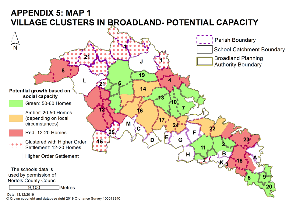
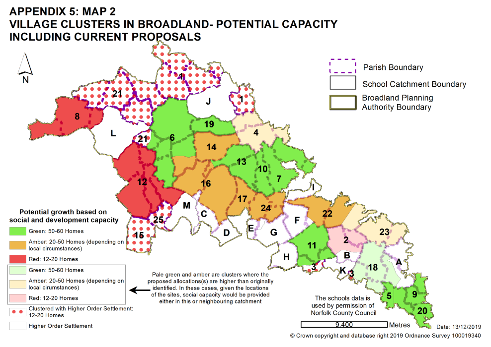
In addition to the existing commitment of 995 homes in the village clusters in Broadland, new site allocations are made in the GNLP Sites Plan for the following number of homes in village clusters in Broadland through this plan. Please note that some parishes cluster with settlements higher in the settlement hierarchy e.g. Blickling, Burgh & Tuttington and Oulton cluster with Aylsham as it provides the local primary school. The table only shows the housing numbers for the village clusters, with housing numbers for the higher order settlements set out in policies 7.1 to 7.3 of the plan.
|
Map Reference
|
Total Dwellings |
Village Cluster |
|
1 |
0 |
Aylsham, Blickling, Burgh & Tuttington and Oulton |
|
|
Main Town |
Aylsham |
|
0 |
Blickling |
|
|
0 |
Burgh & Tuttington |
|
|
0 |
Oulton |
|
|
2 |
12-20 |
Blofield Heath and Hemblington |
|
12-20 |
Blofield Heath |
|
|
0 |
Hemblington |
|
|
3 |
0 |
Brundall and Postwick with Witton |
|
|
Key Service Centre |
Brundall |
|
0 |
Postwick with Witton |
|
|
4 |
30-40 |
Buxton with Lamas and Brampton |
|
30-40 |
Buxton with Lamas |
|
|
0 |
Brampton |
|
|
5 |
0 |
Cantley |
|
6 |
30-40 |
Cawston with Brandiston and Swannington |
|
30-40 |
Cawston |
|
|
0 |
Brandiston |
|
|
0 |
Swannington |
|
|
7 |
20-25 |
Coltishall with Horstead Belaugh |
|
20-25 |
Coltishall |
|
|
0 |
Horstead |
|
|
0 |
Belaugh |
|
|
8 |
12-15 |
Foulsham and Themelthorpe |
|
12-15 |
Foulsham |
|
|
0 |
Themelthorpe |
|
|
9 |
30-40 |
Freethorpe, Halvergate and Wickhampton |
|
30-40 |
Freethorpe and Wickhampton |
|
|
0 |
Halvergate |
|
|
10 |
0 |
Frettenham |
|
11 |
0 |
Great and Little Plumstead |
|
12 |
15-20 |
Great Witchingham, Lenwade, Weston Longville, Alderford, Attlebridge, Little Witchingham and Morton on the hill |
|
15-20 |
Great Witchingham and Lenwade |
|
|
0 |
Weston Longville |
|
|
0 |
Alderford |
|
|
0 |
Attlebridge |
|
|
0 |
Little Witchingham |
|
|
0 |
Morton on the hill |
|
|
13 |
0 |
Hainford and Stratton Strawless |
|
0 |
Hainford |
|
|
0 |
Stratton Strawless |
|
|
14 |
0 |
Hevingham |
|
15 |
Honingham (clustered with Easton in South Norfolk) |
|
|
|
Norwich Urban Area |
Easton |
|
12 |
Honingham |
|
|
16 |
30-40 |
Horsford, Felthorpe and Haveringland |
|
30-40 |
Horsford |
|
|
0 |
Felthorpe |
|
|
0 |
Haveringland |
|
|
17 |
20-30 |
Horsham and Newton St Faiths |
|
18 |
50-60 |
Lingwood & Burlingham, Strumpshaw and Beighton |
|
50-60 |
Lingwood & Burlingham |
|
|
0 |
Strumpshaw |
|
|
0 |
Beighton |
|
|
19 |
25-35 |
Marsham |
|
20 |
40-60 |
Reedham |
|
21 |
0 |
Reepham, Booton, Guestwick, Heydon, Salle and Wood Dalling |
|
|
Key Service Centre |
Reepham |
|
0 |
Botton |
|
|
0 |
Guestwick |
|
|
0 |
Heydon |
|
|
0 |
Salle |
|
|
0 |
Wood Dalling |
|
|
22 |
12-15 |
Salhouse, Woodbastwick and Ranworth |
|
12-15 |
Salhouse |
|
|
0 |
Woodbastwick |
|
|
0 |
Ranworth |
|
|
23 |
20-25 |
South Walsham and Upton with Fishley |
|
20-25 |
South Walsham |
|
|
0 |
Upton with Fishley |
|
|
24 |
0 |
Spixworth and Crostwick |
|
0 |
Spixworth |
|
|
0 |
Crostwick |
|
|
25 |
0 |
Taverham and Ringland |
|
|
Norwich Urban Area |
Taverham |
|
0 |
Ringland |
Settlements higher in the Hierarchy
See policies 7.1 to 7.3 for housing allocations in the following locations.
|
Map Reference |
Settlement |
|
|
A |
Acle |
Key Service Centre |
|
B |
Blofield |
Key Service Centre |
|
C |
Drayton |
Norwich Urban Area |
|
D |
Hellesdon |
Norwich Urban Area |
|
E |
Old Catton |
Norwich Urban Area |
|
F |
Rackheath
|
Norwich Urban Area |
|
G |
Sprowston
|
Norwich Urban Area |
|
H |
Thorpe St Andrew |
Norwich Urban Area |
|
I |
Wroxham |
Key Service Centre |
|
J |
Aylsham |
Main Town |
|
K |
Brundall |
Key Service Centre |
|
L |
Reepham |
Key Service Centre |
|
M |
Taverham |
Norwich Urban Area |