Draft Greater Norwich Local Plan – Part 1 The Strategy
SECTION 5 – THE STRATEGY
POLICY 1 THE SUSTAINABLE GROWTH STRATEGY
Introduction
- This document meets the National Planning Policy Framework's (NPPF) primary purpose for a local plan by providing the planning strategy for the pattern and scale of development to meet growth needs in Greater Norwich from 2018 to 2038. It also provides some indication of a "direction of travel" for future beyond 2038 by suggesting potential opportunities for longer term locations for growth.
- The policy sets out the broad strategic approach, which is illustrated on the draft key diagram below. It also provides the context for subsequent more detailed strategic locational, thematic and sites policies in the plan.
- Achieving sustainable development is at the heart of the planning system. This means striving to meet social, economic and environmental needs to provide a good quality of life for existing and future generations. The aim is to retain and enhance the distinctive qualities of Greater Norwich and create environmentally sustainable, resilient and socially inclusive communities. As required by the NPPF, policy 1 promotes sustainable development.
- The strategy takes a flexible approach in what will be a time of rapid change in how we work, travel and live owing to expected technological, economic and environmental changes. It aims to make the most of Greater Norwich's substantial economic growth potential to develop its leading role in the national economy and to meet housing need, whilst also protecting and enhancing the special environment of our area and promoting low carbon development.
- The strategy meets national planning policy requirements, is informed by consultation feedback and is based on an extensive evidence base covering a wide variety of issues including infrastructure needs, Habitats Regulations Assessment (HRA) considerations and Sustainability Appraisal (SA).
- The policy establishes that five-year housing land supply will be calculated across the whole of the three districts and commits the councils to reviewing the plan five years after adoption.
Employment Growth Needs
- The NPPF requires local plans to set out an economic strategy.
- Building on recent success in terms of the delivery of new jobs, the overall target for jobs growth is for an increase of 33,000 jobs from 2018 to 2038. This figure has been established through local trend-based evidence[52].
- Providing the right sites in the right places for sectors with the greatest economic potential will support continued growth and a vibrant economy. Evidence[53] shows that:
- a range of sectors will drive economic and employment growth, many of which are within high value knowledge-intensive sectors that are increasingly important to the wider UK economy. Greater Norwich is home to several internationally recognised businesses and boasts a diverse property portfolio. Its increasingly entrepreneurial economy is underpinned by a strong foundation of academic and commercial research, making it well positioned nationally and internationally to compete for future business investment as part of the Cambridge Norwich Tech Corridor as well as continuing to grow its own business base;
- growth potential is greatest in five high impact sectors identified in the Norfolk and Suffolk Economic Strategy[54]: advanced manufacturing and engineering; agri-tech; energy; ICT/digital culture; and life sciences;
- the total amount of allocated and permitted employment land in 2018 is broadly enough to provide for expected and promoted growth, so the policy does not make significant additional allocations of employment land beyond those already identified in existing local plan documents.
- This plan therefore allocates employment sites totalling around 360 hectares including strategic employment land in Norwich City Centre, the Norwich Airport area, Rackheath, Broadland Business Park, Broadland Gate, Norwich Research Park (NRP), Wymondham/Hethel, Longwater and the Food Enterprise Park. These are set out in the Key Diagram and in policy 1. The strategic employment locations provide for growth of all the key sectors and are supported by good quality infrastructure and nearby housing, either existing or planned.
- Parts of the NRP have Enterprise Zone status with simplified planning rules, business rate discounts and superfast broadband designed to promote research-based business growth. The Food Enterprise Park has Food Enterprise Zone status and a Local Development Order on parts of the site to encourage and support food production, processing and agriculture through the co-location of commercial enterprises.
- The strategic sites contribute to the Cambridge Norwich Tech Corridor, supporting a globally significant axis between the Cambridge University and UEA/NRP. The Tech Corridor links to other significant growth corridors: London-Stansted-Cambridge and the Cambridge - Milton Keynes-Oxford Arc (CaMkOx).
- Supporting and demonstrating a link to nationally significant growth corridors will assist in attracting inward investment and accessing funding opportunities as Government funding will be linked to the delivery of the Norfolk and Suffolk Economic Strategy and the emerging Local Industrial Strategy for Norfolk and Suffolk[55].
- The Greater Norwich Local Plan also allocates land and allows for additional windfall delivery of smaller scale sites to provide for jobs growth elsewhere in the urban area, towns and villages, providing local job opportunities and supporting small-scale businesses and a vibrant rural economy.
- Evidence shows that there is an underlying demand for good quality office growth and employment space in Norwich city centre. The policies for the economy (policy 6) and for Norwich urban area (policy 7.1) address the need to ensure that high density employment uses are concentrated in highly accessible locations, particularly in the city centre.
Housing Growth Needs
- The existing commitment[56] of housing land at April 2019 is large and shapes the GNLP strategy. The existing allocations, including Site Allocation plans, Area Action Plans and Neighbourhood Plans, derive from the Joint Core Strategy (JCS). These allocations have been demonstrated to be sustainable and, except for later phases of some larger sites where delivery is unlikely before 2038, they are included in this strategy. This deliverable commitment, along with the homes delivered since the start of the plan period in April 2018, provides 82% of the total housing growth identified in this plan to 2038.
- The Government produced a revised standard methodology for identifying local housing need in 2019[57]. Table 6 below sets out how the resulting total housing figure from 2018 to 2038 for the GNLP has been established using the standard methodology and including a buffer to ensure delivery:
Table 6 Establishing the Plan's total housing figure
|
|
Number of Homes |
Explanation |
|
|
A |
Local housing need (2018 to 2038) |
40,541 |
The minimum local housing need figure has been identified using the Government's standard methodology. |
|
B |
Delivery 2018/2019 |
2,938 |
The number of homes built 2018/2019 (including student accommodation and housing for the elderly) |
|
C |
Existing commitment (at April 2019) to be delivered to 2038 |
33,565 |
The existing commitment is the undelivered sites which are already allocated and/or permitted, with parts of or whole sites unlikely to be delivered by 2038 excluded. |
|
D |
New allocations |
7,840 |
These are the homes to be provided on new sites currently proposed to be allocated through the GNLP (6,640) and the South Norfolk Village Clusters Housing Sites Allocation Plan (1,200). |
|
B + C + D |
Total housing figure |
44,343 |
Delivery (B), commitments (C) and new allocations (D). This currently provides a 9% buffer to cater for any non-delivery of sites to ensure delivery of local housing need. The publication version of the plan will aim to provide a minimum 10% buffer (a minimum of a further 250 homes) which is likely to be provided through a combination of additional sites proposed through this consultation and contingency sites identified in this draft plan. |
- In line with the above figures, policy 1 provides for around 44,500 new homes, with a 9% buffer to ensure delivery. In addition to the existing commitment of 1,349 homes, a minimum of 1,200 of these homes will be provided in village clusters in South Norfolk. Sites to provide these homes will be allocated in the South Norfolk Village Clusters Housing Site Allocations document.
Windfall developments
- Windfall developments provide additional potential for housing delivery not counted in the above table. The policy supports appropriate windfall development, including sites in and adjacent to villages and small brownfield sites. Based on previous local trends, the likely scale of windfall development is in the region of 3,870 dwellings between 2018 and 2038. Demand will determine whether windfall development is instead of, or in addition to, allocated growth.
- Policy 7.5 allows for limited further windfall development on very small sites of up to 3 dwellings in each parish during the plan period.
- A contingency site at Costessey for around 1,000 homes is included in this plan should this prove to be required due to low delivery of allocated housing sites. The settlement of Wymondham may also be considered for contingency sites to provide an additional 1,000 homes if required, though no specific sites have been identified at this time.
- The Government encourages authorities to consider higher levels of growth than that required to meet local housing need, particularly where there is the potential for significant economic growth. Our overall approach, including to windfalls and contingency, builds in flexibility to support higher than trend economic growth incorporating the Greater Norwich City Deal.
The Growth Strategy
- To ensure sustainable development, minimise carbon emissions, promote strong, resilient, inclusive and vibrant communities and meet other Government requirements set out in the NPPF, the strategy for the location of growth:
- Maximises brownfield development and regeneration opportunities, which are mainly in Norwich. The brownfield/greenfield split for new homes in the plan is 27%/73%;
Note: At this stage uncertainty remains about a potentially key site at Carrow Works. The figure for additional homes in Norwich in policy 1 includes an allowance for 1,200 new homes at the site. This figure could be amended depending on circumstances, which may an impact on the Publication (Regulation 19) version of the plan.
- Broadly follows the settlement hierarchy set out in policy 1 (the Norwich urban area; main towns; key service centres and village clusters) in terms of scales of growth as this reflects access to services and jobs;
- Focusses most of the growth in locations with the best access to jobs, services and existing and planned infrastructure in and around the Norwich urban area and the Cambridge Norwich Tech corridor;
- Allocates strategic scale housing sites (1,000 dwellings +) in accessible locations;
- Allocates a significant number of medium scale and smaller scale sites in the urban area, towns and villages, providing a balanced range of site types to allow for choice, assist delivery and allow smaller scale developers and builders into the market. Overall, 12% of the homes allocated through the plan are on sites of no larger than 1 hectare, meeting national requirements[58];
- Sets a minimum allocation size of 12-15 dwellings to ensure that a readily deliverable amount of affordable housing is provided on all allocated sites.
- The strategy for the distribution of growth set in policy 1 takes account of the above principles, the scale of existing and deliverability of commitment and assessments of sites submitted to the GNLP.
The Settlement Hierarchy
- Housing growth is distributed in line with the following settlement hierarchy:
- The Norwich urban area which consists of Norwich and the built-up parts of the fringe parishes of Colney, Costessey, Cringleford, Drayton, Easton, Hellesdon, Old Catton, Sprowston, Taverham, Thorpe St. Andrew, Trowse and the remainder of the Growth Triangle.
- The main towns which are Aylsham, Diss (including part of Roydon), Long Stratton, Harleston and Wymondham.
- The key service centres which are Acle, Blofield, Brundall, Hethersett, Hingham, Loddon/Chedgrave, Poringland/Framingham Earl, Reepham and Wroxham.
- Village clusters which cover the remainder of the Greater Norwich Local Plan area.
- Table 7 below sets out the amount and proportion of growth in the different settlement hierarchy areas established by the strategy and provides estimates for homes there will be in each area in 2038.
Table 7 Housing growth 2018 to 2038 (figures rounded)
|
Area |
Homes 2018 |
Homes 2038 (and increase) |
Increase % |
% of total housing growth |
|
Norwich urban area |
106,100 |
136,660 (+30,560) |
29 |
69 |
|
The Main Towns |
19,400 |
25,742 (+ 6,342) |
33 |
14 |
|
The Key Service Centres |
15,900 |
19,317 (+ 3,417) |
21 |
8 |
|
Village clusters |
46,100 |
50,124 (+ 4,024) |
9 |
9 |
|
Total |
187,500 |
231,843 (+ 44,343) |
24 |
|
- No new settlement is proposed at this time as a significant proportion of the allocated sites are strategic scale commitments of 1,000 homes plus and the establishment of any new settlement is likely to take a long time. However, three new settlement sites have been proposed (at Honingham Thorpe, Hethel and Silfield). The longer-term development of a new settlement could be a suitable option in the future. This should be considered in the next review of this plan.
The strategic growth area
- The strategy distributes around 78% of the growth in the "Strategic Growth Area". This area is broadly defined on the Key Diagram and shown in map 7 to include:
- The main Cambridge Norwich Tech Corridor area, including Norwich, the North East Growth Triangle, the remainder of the Norwich Fringe, Hethersett and Wymondham;
- All the strategic employment areas in the plan;
- All but one of the strategic scale housing growth locations (the exception is Long Stratton);
- High quality public transport, road and cycling infrastructure (both existing and planned) and
- The great majority of brownfield sites in the area.
- Identifying this area promotes the strategic economic strengths and sectors of Greater Norwich. By linking to other regional growth corridors, it places Greater Norwich firmly on the national stage for growth and accessing external funding.
- With Norwich playing an anchoring role in the strategic growth area, it also recognises the role the city plays as a driver of the regional economy, supporting the vitality and regeneration of the city centre, including maximising the potential of brownfield sites.
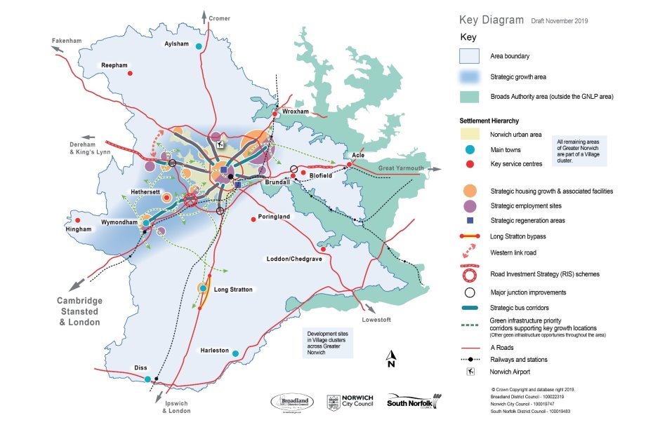
The Key Diagram
- Strategic local plans are required to include a Key Diagram which illustrates key elements of the strategy in the plan on an indicative map.
KEY DIAGRAM
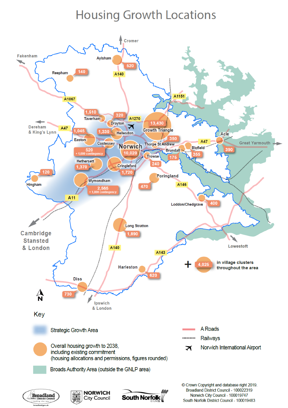
117. Map 7 below provides further detail for housing by illustrating the location and scale of housing growth allocated through the plan across Greater Norwich.
Map 7 Housing Growth Locations
POLICY 1 – THE SUSTAINABLE GROWTH STRATEGY
Sustainable development and inclusive growth are supported by delivery of the following between 2018 and 2038:
- to meet the need for around 40,550 new homes, sites are committed[59] for a minimum of 44,340 new homes;
- to aid delivery of 33,000 additional jobs and support key economic sectors, around 360 hectares of employment land is allocated, and employment opportunities are promoted at the local level;
- supporting infrastructure will be provided in line with policies 2 and 4;
- environmental protection and enhancement measures including further improvements to the green infrastructure network will be delivered.
The sustainable growth strategy is illustrated in the Key Diagram on page 48.
SETTLEMENT HIERARCHY
The settlement hierarchy is:
- Norwich urban area (Norwich and Norwich Fringe[60])
- Main towns
- Key service centres
- Village clusters.
Growth is distributed in line with the settlement hierarchy to provide good access to services, employment and infrastructure. It is provided through urban and rural regeneration, along with sustainable urban and village extensions.
Most of the housing, employment and infrastructure growth is focussed in the Strategic Growth Area illustrated on the Key Diagram. This includes Greater Norwich's part of the Cambridge Norwich Tech Corridor, including the Norwich urban area, Hethersett and Wymondham and key strategic jobs sites at Hethel and the Norwich Research Park. Growth is also focussed in towns and villages to support vibrant rural communities.
HOUSING
Housing commitments are located to meet the need for homes across the area, providing good access to services, facilities and jobs, supporting sustainable urban and rural living. Accordingly, housing commitments are distributed as follows:
|
Area |
Existing deliverable commitment (including uplift and delivery 2018/19) |
New allocations |
Total minimum deliverable housing commitment 2018 - 2038 |
|
|
Norwich urban area |
26,165 |
4,395 |
30,560 |
|
|
The main towns of Wymondham, Aylsham, Diss (with part of Roydon), Harleston and Long Stratton |
5,092 |
1,250 |
6,342 |
|
|
The key service centres of Acle, Blofield, Brundall, Hethersett, Hingham, Loddon / Chedgrave, Poringland / Framingham Earl, Reepham and Wroxham |
2,902 |
515 |
3,417 |
|
|
Village clusters (see appendix 5 details of the clusters) |
In the remaining parts of Broadland (see policy 7.4 and the GNLP Sites Plan for specific sites) |
995 |
Up to 480[61] |
4,024 |
|
In South Norfolk (see policy 7.4 and the South Norfolk Village Clusters Housing Site Allocations document for specific allocations) |
1,349 |
A minimum of 1,200 |
||
|
Total |
36,503 |
7,840 |
44,343 |
|
Policies 7.1 to 7.5 provide details on distribution and the Sites document provides individual site policies. Individual site policies for villages in South Norfolk will be in the South Norfolk Village Clusters Housing Site Allocations document.
To provide choice and aid delivery of housing, proposals for additional "windfall" housing growth will be considered acceptable in principle at appropriate scales and locations where they would not have a negative impact on the character and scale of the settlement, and subject to other local plan policies:
- Within settlement boundaries in accordance with the above settlement hierarchy;
- Elsewhere in village clusters, subject to the requirements of policy 7.4.
- On sites of up to 3 dwellings in all parishes, subject to the requirements of policy 7.5.
Plan review and five-year housing land supply
This plan will be reviewed 5 years after adoption. Five-year housing land supply will be calculated across the whole of the three districts. The plan provides enough allocations to provide a five-year housing land supply on adoption[62].
ECONOMY
Strategic employment locations in the Key Diagram are protected from other forms of development and will support both a broad range of employment and key economic sectors as set out in policy 6. The strategic locations are:
- Norwich city centre;
- the Norwich Airport area;
- Browick Interchange, Wymondham;
- Longwater;
- Rackheath;
- Broadland Business Park;
- Broadland Gate;
- Norwich Research Park;
- Hethel and
- The Food Enterprise Park at Easton/Honingham.
In addition, smaller scale employment sites are allocated in urban areas, towns and large villages to provide local job opportunities, supporting small businesses and vibrant urban and rural economies.
INFRASTRUCTURE
The sustainable growth strategy will be supported by improvements to the transport system, green infrastructure and services.
Alternative approaches
Housing and job numbers
The local plan's preferred option is to support growth of around 33,000 new jobs and a minimum of around 40,540 new homes between 2018 and 2038. These figures are based on our evidence of employment growth needs and the use of the Government's standard methodology for assessing housing need. To ensure delivery, identified sites provide for a significant excess of land for employment and around 9% additional dwellings. Providing additional land as a buffer is a standard approach to ensure delivery. In addition, the plan provides significant flexibility with no phasing restriction on sites, the identification of contingency sites and the approach to future windfall development.
The jobs targets are derived from an analysis of "enhanced growth". An alternative would be to plan for lower levels of economic growth, but this is not consistent with local objectives and is not considered to be reasonable. Alternatively, the plan could adopt higher jobs targets but, as it already provides for enhanced growth and with current economic uncertainties, significantly higher targets are unlikely to be achievable. The over allocation of land provides the flexibility to facilitate higher growth should it occur.
In the absence of any exceptional circumstances setting a lower housing target than derived from the Government's standard methodology would be inconsistent with the NPPF and is not considered to be a justifiable alternative. The NPPF does encourage a higher housing requirement to be considered. This is not the preferred alternative as evidence of delivery over the medium and longer term suggests that higher targets are unlikely to be achievable or deliverable. Setting a higher target than can be achieved undermines the plan-led system. However, if additional need and demand for housing materialises, it can be facilitated through the flexibility built into the local plan.
The plan could identify a smaller delivery buffer and/or include windfall development as part of the housing provision total. This is not the preferred alternative as it would reduce the chances of meeting housing need and would take away the flexibility that allows the plan to respond to changing circumstances. A larger delivery buffer might be considered. However, the preferred approach is considered to provide enough flexibility.
The Settlement Hierarchy and the distribution of housing
The preferred settlement hierarchy follows a typical approach reflecting materially different levels of service between different types of places. It is innovative in grouping all smaller villages and the countryside into village clusters. An alternative would be to revert to a similar approach to the existing local plans for the area with the separate identification of service villages, other villages and countryside.
This is not preferred as the Councils consider that a cluster approach better reflects the way people access services in rural areas and enhances social sustainability by facilitating higher levels of growth in small villages. Where individual settlements fit within the hierarchy could be reconsidered but the preferred categorisation best fits the evidence of service provision. The allocation of sites in the clusters in South Norfolk will be made through a separate plan.
The distribution of development in the plan tends to focus more growth higher up the hierarchy maximising the use of brownfield land and providing for urban extensions close to existing jobs, services and infrastructure. Within that general approach several alternative approachescan be identified for the distribution of development. The consultation in early 2018 on Growth Options (see pages 31 to 35) identified six reasonable alternatives:
Option 1 - Concentration close to Norwich
Option 2 – Transport corridors
Option 3 – Supporting the Cambridge to Norwich Tech Corridor
Option 4 - Dispersal
Option 5 – Dispersal plus New Settlement
Option 6 – Dispersal plus Urban Growth
The preferred option in this plan combines concentration of most of the development in and around Norwich and on the Cambridge Norwich Tech Corridor, with an element of dispersal to villages to support thriving rural communities. Whilst detailed variations on this option may be reasonable, it is considered that the preferred approach provides the best balance across the range of objectives of the plan.
Review and Five-Year Land Supply
The preferred option commits to a review of the plan after 5 years. As this is good planning practice to ensure that growth needs are met and is required by Government, a longer period is not considered to be a justifiablealternative. While a shorter review period could be reasonable, experience suggests it is unlikely to be achievable.
Government policy allows 5-year land supply to be calculated on a district wide basis, or across boundaries where local authorities work together. While either could be considered, the preferred approach is to calculatethe 5-year land supply across the whole of the three districts. This better reflects the single local plan and ongoing cooperation on delivery; the inter-relationship of social and economic needs throughout the area; and the recognition that much of the area falls within a single core housing market area.
Economy
The identification of strategic employment locations highlights opportunities for large scale growth, helps prioritise infrastructure investment and maximises the existing strengths of the local economy. This is coupled with the promotion of local employment opportunities. No alternative approach is identified.
Infrastructure
New development must be supported by additional infrastructure of all kinds. Policies 1 and 4, along with appendix 1, set out the infrastructure requirements to serve the growth in Greater Norwich based on evidence in the Greater Norwich Local Plan Infrastructure Needs Report. This provides flexibility to allow for any changing needs over time, and noalternative approach is identified.
Consultation Questions for Policy 1 – The Sustainable Growth Strategy
- (89) Do you agree with the proposed Settlement Hierarchy and the proposed distribution of housing within the hierarchy?
- (80) Do you support, object or wish to comment on the approach for housing numbers and delivery?
- (26) Do you support, object or wish to comment on the approach for the Economy?
- (36) Do you support, object or wish to comment on the approach to Review and Five-Year Land Supply?
- (33) Do you support, object or wish to comment on the approach to Infrastructure?
POLICY 2 - SUSTAINABLE COMMUNITIES
Introduction
- The Sustainable Communities policy is wide ranging. It aims to ensure that the design of development is high quality, contributes to the establishment and maintenance of resilient and inclusive communities, promotes low carbon development and helps to address climate change. It is a key strategic policy, covering many aspects of the vision and objectives of the plan. Together with policy 3, which focuses on the design of development reflecting local character and sense of place using local design guidance, the policy promotes well-designed places as required by section 12 of the NPPF.
- The policy covers ten key social, economic and environmental issues which all developments must address through their design. These are set out in table 8 below. The table also references other relevant plan policies and supporting supplementary planning documents.
Table 8 - Key issues addressed by policy 2
|
Issue number in policy 2 |
Requirement and justification |
|
Developments are required to provide convenient, safe and sustainable access to new on-site services and facilities or to existing facilities as appropriate. This reduces the need to travel and provides local access to services and facilities, supporting their viability. Strategic infrastructure is provided for through policy 4. |
|
The policy requires development to allow for the delivery of new technologies. Such a strategic approach is important for economic growth and will have environmental and social benefits. The policy encourages developers to work with service providers on the delivery of a broad range of existing, developing and future technologies, with broadband and mobile phone networks a current focus. Developers must therefore ensure broadband infrastructure is provided for new developments. To do this, they should register new sites with broadband infrastructure providers. The preference is that all residential developments over 10 dwellings and all employment developments will provide Fibre to the Premises (FTTP) for high connection speeds. For smaller schemes, the expectation is that FTTP will be provided where practical. Where this is not possible, then non-Next Generation Access (NGA) technologies that can provide speeds more than 24Mbps should be delivered. The policy also provides the basis for more detailed development management policies or supplementary planning documents for measures to support new technologies in times of rapid change, including the use of electric vehicles. |
|
Developments are required to provide on-site green infrastructure appropriate to their scale and location. The three main benefits of green infrastructure: biodiversity gain; the promotion of active travel and the reduction of flood risk, are key NPPF priorities. On-site provision will link and contribute to the further development of an area-wide green infrastructure network, promoted through policies 3 and 4, which has now been in development in Greater Norwich for over a decade. |
|
In line with the NPPF, developments are required through this policy to make effective use of land. To do this, the policy establishes minimum densities for different part of the area. It requires higher densities in the most sustainable locations. These are mainly in Norwich and in the city centre where, dependent on design issues, high densities have and can be delivered. It also establishes a minimum density elsewhere to ensure the effective use of land. The policy will be used with policy 3 which focuses on design creating a distinct sense of place and reflecting local character. |
|
The NPPF requires local plans to recognise the intrinsic character and beauty of the countryside. Accordingly, the policy requires development to respect landscape character, based on existing and any future landscape character assessments, and protects locally valued landscapes from inappropriate development. It continues the well-established approach in Greater Norwich of having strong landscape protection policies. To do this, it provides the strategic policy basis for more detailed, location specific development management policies covering the strategic gaps and landscape settings including river valleys, undeveloped approaches to Norwich and the setting of the Broads. This is the most suitable approach to landscape protection locally given that Greater Norwich does not have the exceptional circumstances required by Government to establish a Green Belt. |
|
The policy requires appropriate development to be designed to manage travel demand, promote active and sustainable travel and to ensure parking is addressed effectively. The design of development, as well as its location[63] and the local availability of services addressed in point 1 of this policy, play an important role in determining how much and how people travel. This is particularly the case on larger sites where good design can significantly influence travel habits. In addition, the policy requires sites to be designed to accommodate parking without impacting on the amenity of residents. |
|
In line with the NPPF, this element of the policy covers social aspects of the design of development. The requirement focuses firstly on ensuring services are accessible either within or from new developments. Secondly, the policy covers the creation and maintenance of resilient, safe and inclusive communities in which all members of society can interact. Thirdly, the design of development is required to promote healthy and active lifestyles. |
|
This part of the policy covers a range of the environmental issues that new development must focus on, most of which have an impact on addressing climate change. Point 9 provides the strategic basis for more detailed development management policies or detailed guidance on resource efficiency, pollution, overheating and ground conditions. |
|
Point 9 of the policy covers the range of issues related to water affecting new development, including flood risk, water quality, sustainable drainage (SUDS) and water efficiency. As evidenced by the Strategic Flood Risk Assessment, the great majority of development promoted through this plan avoids areas at risk of flood. Any mitigation required, mainly in parts of Norwich city centre and East Norwich, will come forward as part of specific developments and will be guided by a level 2 Strategic Flood Risk Assessment. Government policy expects local planning authorities to adopt proactive strategies to adapt to climate change, taking into account water supply and demand considerations. It allows local plans to set a higher standard of water efficiency than the Building Regulations where evidence justifies it. For housing development, only the higher Building Regulations standard for water prescribed by Government (110 litres per person per day) can applied through local plans and more demanding standards cannot be set. If the potential to set more demanding standards locally is established by the Government in the future, these will be applied in Greater Norwich. For non-housing development, broadly equivalent standards can be required using BREEAM assessments. In Greater Norwich, evidence and justification on the need for water efficiency measures includes:
Implementation of the standards for water efficiency will be supported by an updated advice note. |
|
Point 11 of the policy requires development to be designed and orientated to minimise energy use, an easily achievable and cost-effective means of promoting low carbon development. It also supports decarbonised energy supplies locally by promoting decentralised, renewable and low carbon energy generation and battery storage, as well as energy efficiency in new developments. This approach to energy in new developments is required as:
Policy 2 therefore establishes standards for energy efficiency in new housing and non-housing development. Further detail on how this will be achieved will be set out in a future Energy Policy Implementation Note or SPD. This approach is deliberately flexible as:
Evidence shows the policy is viable[68]. Investment in energy efficiency in new development will have the significant additional benefits of reducing energy costs for the users of new development, as well as carbon savings. The policy also requires larger developments (100 dwellings plus or 10,000 square metres plus for non-residential development) to maximise opportunities for the use of sustainable local energy networks. This requirement is also set in line with the recommendations of the Greater Norwich Energy Infrastructure Study. The study sets out that there are likely to be constraints on the electricity grid and recommends ways to avoid or reduce the costs of improved network connection which are relevant to all larger sites, and to those sites affected by grid constraints named in appendix 1. Measures to implement point 6 of the policy, to be evidenced on a site by site basis through the Sustainability Statement, could include:
|
Implementation
- The policy will be implemented through:
- Major developments[69] being required to submit a Sustainability Statement. This will besupported by supplementary planning guidance. The purpose of the statement is to show, on a site by site basis, how the varied aspects of the policy are addressed. The policy encourages, but does not require, the use of the Building for Life 12[70] design tool, or any equivalents or future successors. This provides flexibility in how applicants produce their sustainability statements for housing developments. The policy also encourages master planning using a community engagement process on larger sites (200 dwellings plus or 20,000 square metres for non-residential development) and requires it on sites of 500 dwellings plus or 50,000 square metres. The purpose of this is to promote effective community engagement in the design of larger schemes. It also includes a requirement for Health Impact Assessments for specific types of development to show how health care needs will be provided for.
- Housing developments of 100 dwellings or more being required to submit a Delivery Statement. This statement is aimed at supporting timely delivery of development, a priority for this plan. It requires developers to set out the timing of the delivery of developments in their statements accompanying planning applications. Where delivery does not happen, it enables the local authorities to consider the use of legal powers to promote delivery, including compulsory purchase.
- All minor developments also being subject to the policy's requirements. This will be assessed on a case by case basis, taking into account site characteristics and proposed uses. Minor developments are not required to submit a Sustainability Statement. This is in line with the threshold for national requirements for Design and Access statements for major developments only and ensures that planning application submission requirements are proportionate;
- Existing development management policies, which will be updated in due course, which detail some policy aspects such as the locations of areas protected from inappropriate development under landscape policies.
- Supplementary Planning Documents and guidance (see table above).
POLICY 2 – SUSTAINABLE COMMUNITIES
Development must be high quality, contributing to delivering inclusive growth in mixed, resilient and sustainable communities and to mitigating and adapting to climate change, assisting in meeting national greenhouse gas emissions targets[71]. To achieve this, development proposals are required as appropriate to:
- Ensure safe, convenient and sustainable access to on-site and local services and facilities including schools, health care, shops, leisure/community/faith facilities and libraries;
- Allow for delivery of new and changing technologies (including broadband, fibre optic networks, telecommunications and electric vehicles);
- Contribute to multi-functional green infrastructure links, including through landscaping, to make best use of site characteristics and integrate into the surroundings;
- Make efficient use of land with densities dependent on site characteristics, with higher densities and car free housing in the most sustainably accessible locations in Norwich. Indicative minimum densities are 25 dwellings per hectare across the plan area and 40 in Norwich[72].
- Respect, protect and enhance landscape character, taking account of landscape character assessments or equivalent documents, and maintain strategic gaps and landscape settings, including river valleys, undeveloped approaches and the character and setting of the Broads;
- Provide safe and suitable access for all users, manage travel demand and promote public transport and active travel within a clearly legible public realm, whilst also integrating parking and providing a high standard of amenity;
- Create inclusive, resilient and safe communities in which people of all ages have good access to services and local job opportunities, can interact socially, be independent and have the opportunity for healthy and active lifestyles;
- Be resource efficient, support sustainable waste management, reduce overheating, protect air quality, minimise pollution and take account of ground conditions;
-
Minimise flood risk, including reducing the causes and impacts of flooding, supporting a catchment approach to water management and using sustainable drainage. Development must also protect water quality and be water efficient. To achieve the latter:
- Housing development will meet the Building Regulations part G (amended 2016) water efficiency higher optional standard;
- Non-housing development will meet the BREEAM "Very Good" water efficiency standard, or any equivalent successor;
If the potential to set more demanding standards locally is established by the Government up to 2038, the highest potential standard will be applied in Greater Norwich.
-
Minimise energy demand through the design and orientation of development and maximise the use of sustainable energy, local energy networks and battery storage to assist growth delivery. This will include:
- All new development will provide a 20% reduction against Part L of the 2013 Building Regulations (amended 2016);
- Appropriate non-housing development of 500 square metres or above will meet the BREEAM "Very Good" energy efficiency standard, or any equivalent successor.
Proposals for free standing decentralised, renewable and/or low carbon energy networks, except for wind energy schemes, will be supported subject the acceptability of wider impacts.
Wind energy schemes will be supported where the proposal is in a suitable area as identified in a neighbourhood plan or other local plan documents.
To assist this broad-based approach:
- Planning applications for major developments will be required to be accompanied by a Sustainability Statement (including Health Impact Assessments as appropriate)[73] showing how development will support the above requirements, with housing development optionally making use of tools such as Building for Life 12 (or any successor). Other developments will meet the policy requirements as appropriate dependent on site characteristics and proposed uses. Flood risk assessments will be provided separately as required by Government guidance.
- Master planning using a recognised community engagement process will be encouraged on larger sites and required for proposed developments of 200 dwellings or 20,000 square metres plus.
Alternative approaches
The preferred approach establishes the requirement for a sustainability statement to accompany planning applications for major developments and masterplans for large developments, to improve the quality of development and ensure that key NPPF priorities are implemented locally. Not requiring such a statement, or modifying its content, could be considered but would make the delivery of sustainable development more challenging.
The justification for the approach to water is wholly compelling. Anglian Water recommends that new development should achieve water neutrality, so that the predicted increase in total water demand due to the development is offset by reducing the demand in the existing community. While water neutrality could be justified, at present, Government policy clearly states that it cannot be made a local plan requirement. Due to the significance of the issue locally, the policy establishes the intention to set more demanding standards if Government changes its policy approach.
The evidence and justification establish a clear need to set a local energy efficiency policy which goes beyond 2013 Building Regulations. The estimated cost of the preferred option for energy, at between £2,000 and £7,000 per dwelling depends on the approach taken to addressing the policy taken on a site by site basis, is viable. As such, it provides a challenging but achievable requirement.
It is not possible to set a greater percentage requirement for energy efficiency than 20%, or to a require a stepped approach to require all development to be carbon neutral by a specific date. Since the cost of this for housing development is likely to be at least £15,000 per dwelling, viability testing has concluded that such an approach could not be taken in Greater Norwich, so is not a justified alternative. If the Government enacts the planned changes to Building Regulations, or forms of policy to implement the Future Homes Standard, this policy approach will be strengthened.
Consultation Questions for Policy 2 –Sustainable communities
- (62) Do you support, object or have any comments relating to the preferred approach to sustainable communities including the requirement for a sustainability statement?
- (50) Do you support, object or have any comments relating to the specific requirements of the policy.
Consultation responses are welcomed on the likely cost of implementing the proposed energy policy approach locally.
POLICY 3 – ENVIRONMENTAL PROTECTION AND ENHANCEMENT
The Built and Historic Environment
- The National Planning Policy Framework states that plans should set out a positive strategy for the conservation and enjoyment of the historic environment, including heritage assets most at risk through neglect, decay or other threats.
- The Greater Norwich area has numerous heritage assets. Consequently, the historic environment is central to the character and quality of life of the Greater Norwich area and is a significant factor in its economic success through encouraging tourism and inward investment. Conserving and enhancing the historic environment will continue to reinforce what makes Greater Norwich an attractive place to live in, work and visit.
- As a long settled and productive area, Greater Norwich also has a significant archaeological heritage which development can help to reveal.
- As such, it is important to recognise that the historic character of the area is made up of a multitude of historic assets. Individually, some may be more important than others, but even the lesser ones are important in contributing to overall character and quality. All the different elements of the historic environment need to be taken into consideration and conserved and enhanced where possible as part of the development of the area.
- The strategic approach to heritage is first to consider the potential location of development, for example does the location itself "fit" well in relation to adjoining settlements, and does it avoid intruding in important views of historic assets? This is addressed through the growth strategy set out in policy 1.
- Following from this, the design of the development needs to respect the historic environment, be appropriate to its setting, seek to enhance the locality and provide measures to further the understanding of local heritage issues. Development should therefore draw upon existing historic character to lead to more positive change in the built and historic environment.
- In certain cases, an element of harm to the historic environment resulting from development is unavoidable. The policy therefore requires such harm to be minimised. Where such harm is identified, its level should be weighed against public benefits in decision making.
- The policy also includes a flexible approach to the use of historic assets to achieve their retention whilst retaining their historic significance. Historic significance potentially covers a broad range of issues such as artistic, aesthetic, architectural, cultural and social considerations.
The Natural Environment
- Reflecting the Government's 25 Year Environment Plan, the NPPFplaces great weight on protecting and enhancing Greater Norwich's rich natural environment. It seeks to ensure that development not only avoids harm to natural environmental assets, but also encourages a local plan policy approach which actively protects, promotes and enhances biodiversity, so that development results in biodiversity net gain.
- A key means of achieving biodiversity net gain is through the NPPF requirement that local plans take a strategic approach to maintaining and enhancing networks of habitats and green infrastructure. The development of a multi-functional green infrastructure network was formalised locally through the Joint Core Strategy in 2011. It is essential that the network continues to be developed into the long-term as green infrastructure aims to link fragmented habitats, allowing the movement of species. It also has other benefits such as reducing flood risk and promoting active travel.
- Tools such as the Defra biodiversity metric should be used to demonstrate the expected biodiversity net gain that will be achieved through development.
- The Environment Bill is currently being considered by Parliament. If implemented as it is currently intended, it will make biodiversity net gain mandatory for all development above specified threshold sizes. If this happens, the policy will be amended in the submission plan to reflect this.
- An interim Habitats Regulations Assessment (HRA)[74]has been published. It identifies in detail how internationally designated ecological habitats and wildlife sites in the wider area, including the Broads and the Norfolk coast, would potentially be impacted by recreational pressures likely to be generated by growth in Greater Norwich. The policy therefore sets a requirement that development mitigates impact on sites protected under the Habitats Regulations Directive.
- The HRA identifies a range of mitigation measures to alleviate additional recreational pressure from additional growth planned in the Greater Norwich Local Plan. These include interventions at the sites themselves, providing suitable alternative natural green space (known as SANGS) and the implementation of a wider programme of green infrastructure improvements.
- The HRA provides further information on SANGS, stating that this could take the form of a new country park containing woodland and waterbodies. This would be in addition to the new country park facilities which are already planned for the Growth Triangle.
- The Joint Core Strategy identified the potential to create a new country park at Bawburgh Lakes to the west of Norwich. It would complement the existing country park to the east of the city at Whitlingham, with the parks linked by the Yare Valley green corridor. Its establishment remains desirable. However, the policy is not site specific as other opportunities, such as a potential country park in woodland to the north west of Horsford may be identified either through local green infrastructure strategies or through other means. New small-scale country parks, such as at Ladybelt Country Park in East Carleton, can provide valuable additional green infrastructure[75].
- A Norfolk-wide study, the Green infrastructure and Recreational Impact Avoidance and Mitigation Strategy, has been commissioned. The results of this will inform the final approach to mitigation taken in the submission version of this plan. The emerging evidence indicates that a specific tariff will be required as part of our mitigation strategy for internationally protected sites, along with a contribution to informal open spaces.
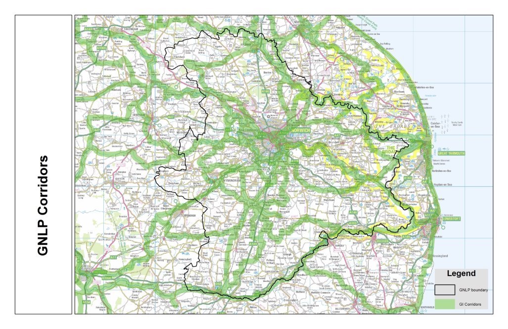
- The draft Norfolk Strategic Planning Framework includes county-wide policy objectives on environmental protection, landscape protection and biodiversity. Work supporting the emerging NSPF includes a county-wide green infrastructure network map which provides the basis for more detailed mapping to support and inform local plans, including the GNLP. The updated green corridors map for Greater Norwich, including links to neighbouring areas, is in map 2 below.
- The policy therefore builds on the success of the JCS to ensure both continued long-term development of the green infrastructure network and that visitor pressure issues on HRA designated sites are addressed. Dependent on changes to Government policy, it is likely that it will be strengthened in the Publication version of the plan to require biodiversity net gain.
Map 8 Green Infrastructure (GI) Corridors
POLICY 3 – ENVIRONMENTAL PROTECTION AND ENHANCEMENT
The Built and Historic Environment
The development strategy of the plan and the sites proposed for development reflect the area's settlement structure of the city, towns and villages, retaining the separate identities of individual settlements.
Development proposals will be required to conserve and enhance the built and historic environment through:
- being designed to create a distinct sense of place and enhance local character taking account of local design guidance and providing measures such as heritage interpretation to further the understanding of local heritage issues;
- avoiding harm to designated and non-designated heritage assets and historic character, and minimising harm if this is not possible;
- providing a continued or new use for heritage assets whilst retaining their historic significance.
Greater levels of protection will be provided according to the statutory status and quality of the built and historic asset.
The Natural Environment
Development proposals will be required to conserve and enhance the natural environment. Key elements of the natural environment include valued landscapes, biodiversity including priority habitats, networks and species, geodiversity, high quality agricultural land and soils. Greater levels of protection will be provided according to the statutory status and quality of the natural asset.
Development should deliver biodiversity net gain wherever possible.
To enhance the natural capital of Greater Norwich, the natural assets and connections between them which form the Green Infrastructure Network illustrated in map 8 will be protected and enhanced. Protection will be achieved through effective management of development in accordance with the policies of the development plan. Enhancement will be achieved through the provision of on-site green infrastructure as appropriate and co-ordination of infrastructure funding and investment, including the Community Infrastructure Levy. This may include the establishment of a new country park or parks, along with additional forms of green infrastructure identified through local green infrastructure strategies.
All housing development is required to mitigate impact on sites protected under the Habitats Regulations Directive.
Alternative approaches
The Built and Historic Environment
The policy delivers the NPPF and follows typical practice. No alternative to the overall approach has been identified.
The Natural Environment
The policy requirements are based on the NPPF and evidence from the Norfolk Green Infrastructure and Recreational Impact Avoidance and Mitigation Strategy. Since Greater Norwich and surrounding areas of Norfolk have several designated ecological sites of international importance, increased visitor impact on these sites resulting from growth in the area must be addressed. The policy provides appropriate mitigation to allow development to go ahead and supports the principles of protecting habitats and promoting biodiversity net gain currently established through the NPPF. As it is a legal requirement to protect the internationally important habitats, no alternatives are identified to the overall approach.
Consultation Questions for Policy 3 – Environmental Protection and Enhancement
POLICY 4 – STRATEGIC INFRASTRUCTURE
Introduction
- The National Planning Policy Framework states that strategic policies should make provision for infrastructure for transport, water, energy, health, education and green infrastructure. This plan is supported by evidence in the Greater Norwich Local Plan Infrastructure Report (GNLPIR)[76].
- As set out in the vision and objectives and the Delivery Statement, delivery of new infrastructure is a priority for the plan. It provides benefits for new and existing communities and is essential to ensure growth is sustainable.
- This policy focusses primarily on the timely delivery of strategic infrastructure to support growth. The infrastructure will be provided by a range of organisations and through a variety of funding sources as detailed in appendix 1. The appendix sets out infrastructure currently identified to support growth from organisations such as utilities companies and health care providers. Since these may be subject to change over time, the Greater Norwich Infrastructure Plan, which supports implementation of the GNLP, will update the information in appendix 1 of this plan annually to take account of any changes.
- As needs may change over time, particularly because of technological changes, the delivery of development will not necessarily be dependent on the specific infrastructure identified in the appendix.
- To promote good local access to facilities, the policy also sets a requirement for development to provide or support local infrastructure, services and facilities. This can be directly through providing land, or indirectly through financial contributions which can include providing good access to existing services and facilities.
- The policy therefore covers strategic transport, energy, water, health and education needs, with a cross reference to other policies in the plan which cover strategic green infrastructure and more local needs.
Transport
- A well-functioning transport system and access to jobs, services and information is vital to the economy of the area and the well-being and quality of life for residents. Making the most of existing transport infrastructure and providing the additional infrastructure required to support growth will help support delivery of the GNLP. To support emissions reductions, it is also important to promote modal shift to active travel and clean public transport, and to support electric vehicle use in a time of rapid technological change.
- Section 9 of the NPPF covers transport issues. It states that transport should be considered from the earliest stages of plan making, to address the potential impacts of development, take advantage of existing and proposed infrastructure and new technology and promote public transport, walking and cycling. Significant development should be focused on locations which are or can be made sustainable, through limiting the need to travel and offering a genuine choice of transport modes. This can help to reduce congestion and emissions and improve air quality and public health. It also recognises that opportunities to maximise sustainable transport solutions will vary between urban and rural areas.
- National, regional and local (county) proposals for transport measures include consideration of the growth needs identified by local plans, integrating development with transport infrastructure needs. Government plans for major roads and there are regional strategies for railways. County led strategies provide for locally significant transport infrastructure. The recognition of and support for transport improvements in the GNLP can be of considerable assistance in applying for funding. The policy consequently identifies and supports strategic and local transport improvements.
- Trunk road (the A11 and A47) improvements are planned by Highways England. In October 2017 it announced a timetable for £300 million of A47 improvements[77] which will dual parts of the road between Peterborough and Great Yarmouth. Contracts were awarded in September 2019 for the three schemes In Greater Norwich:
- Blofield to North Burlingham[78] planned start date 2020-21, planned end date December 2022;
- Thickthorn junction planned start date 2020-21, planned end date 2023[79];
- East Tuddenham to Easton improvement planned start date 2022, planned end date 2023-24[80].
- Government has also announced a Major Road Network (MRN). The MRN comprises local non-trunk roads of national importance and the announcement comes with a fund for improvement. Within the Greater Norwich area, this includes the A140 north and south of Norwich (including the A1270 Broadland Northway) and the A146 connecting Norwich to Lowestoft. Improvements to the A140 include the new roundabout to replace the Hempnall crossroads which was completed in late 2019. The A140 Long Stratton bypass has been given conditional approval by Government. The current programme completion date is the end of 2023.
- A new nine year East Anglian rail franchise commenced in October 2016. This is delivering significant improvements to rail services including more services and faster journeys across the network. Two daily trains are already providing 90-minute journey times between Norwich and London, with plans in place for Norwich to Cambridge services to be extended to Stansted Airport. In addition, long-term development of a direct rail link to Milton Keynes, Oxford and the West remains a priority.
- Two new railway stations are planned for the area. The Growth Triangle Area Action Plan identifies new station sites on the Norwich to Sheringham line at Rackheath and Dussindale to serve these major employment and housing growth areas. Dussindale station has outline planning consent.
- Local transport strategy for the Norwich area is shaped by Norfolk County Council's third local transport plan (2011) and the Norwich Area Transportation Strategy (2013) (NATS). A fourth local transport plan (LTP4) is being progressed together with a review of NATS, known as the Transport for Norwich Strategy (TfN). LTP4 and TfN are being prepared alongside the GNLP.
- TfN will include measures to improve walking, cycling and public transport facilities to support significant modal shift in the urban area during the plan period. This will be required to assist in meeting national targets to achieve zero carbon development by 2050. The measures are likely to feature improvements to sustainable transport networks and interchanges, including Park and Ride enhancements, and a cross valley bus link between UEA and the remainder of Norwich Research Park. Road improvements to enable the other measures are also being considered.
- In the short term, the Norwich area has been successful in securing a place in Government's Transforming Cities (TC) programme which has the potential to bring significant investment to the transport networks in the city and surrounding area. The TfN review is being developed alongside the emerging TC programme. As work is ongoing in relation to sustainable transport projects, it is likely that greater detail on specific projects will be contained in the submission version of this plan in 2020.
- Norfolk County Council has identified the Norwich Western Link as one of its infrastructure priorities. Work continues to develop the scheme in readiness to submit a business case for a large local major scheme to the Department for Transport (DfT). As it develops, the GNLP will reflect progress towards delivery of the scheme and when a route is formally adopted it will need to be shown in the GNLP.
- Transport improvements outside the Transport for Norwich area are dealt with on a local basis. The county council has commenced a programme of Market Town Network Improvement Strategies (NIS). These strategies identify short, medium and long-term actions including the issues associated with long-term growth. Diss was included in the first tranche and will be completed by the end of 2019. Wroxham/Hoveton, Aylsham and Wymondham are in tranche 2 and are at earlier stages of development.
- The policy recognises that Greater Norwich is a mixed urban and rural area in which travel and access issues vary, with the use of the private car being particularly important to the rural economy. It is anticipated that the shift to electric vehicles will assist in reducing emissions in rural areas.
- Strategic transport improvements in policy 4 include rail and airport improvements, along with road improvements including dualling of the A47, the Long Stratton by-pass and the Norwich Western Link Road.
- The policy also supports the TfN strategy and identifies this as the detailed means by which transport improvements across the urban area of Norwich will be developed and delivered, including encouraging walking and cycling, and improving public transport.
- The transport element of the policy will evolve as the work to develop TfN strategy, LTP 4, Transforming Cities programme and Network Improvement strategies continues. This will allow both the policy and the GNLP implementation plan to be more specific and identify any relevant wider transport targets and measures to be captured beyond those required to support growth in the GNLP.
Other strategic infrastructure
Energy
- The Greater Norwich Energy Infrastructure Study (March 2019) concludes that failure to address local energy constraints through local plan policy could threaten the delivery of growth in this plan. These result partly from regulatory barriers to network operators investing in new energy supply infrastructure. Reflecting the requirements of the NPPF, the study highlights the importance of having both positive energy efficiency polices and policies to promote sustainable energy development. This will help both to address climate change and to overcome network constraints.
- The policy reflects the recommendations of the study in relation to improving network supply capacity. Policy 2 reflects its recommendations through policies which aim to reduce the carbon emissions, promote local energy networks and minimise energy demand in new developments.
- Therefore, the policy commits the Greater Norwich authorities to lobbying for improvements to the capacity of the energy supply network by the service provider, UK Power Networks to ensure improvements are delivered to serve growth needs and/or to innovative approaches which could off-set the need for capacity improvements. It particularly highlights the substations at which the study identifies capacity concerns. These are at Sprowston, Peachman Way (Broadland Business Park), Earlham and Cringleford.
Water
- Water supply and disposal infrastructure in Greater Norwich is provided by Anglian Water (AW). Strategic plans, which take account of planned growth and climate change and are subject to Habitats Regulation Assessment (HRA), are in place and are being updated for both water supply and disposal.
- Water supply in Greater Norwich is from groundwater sources and from a river intake from the Wensum. There has been significant recent investment in the river intake to protect water quality in this internationally designated chalk river habitat.
- The emerging water resources plan[81] does not require additional spending on water supply infrastructure to serve growth in Greater Norwich. Investment is planned to transfer water from the Norwich and the Broads water resource zone (WRZ) to the neighbouring Happisburgh and Norfolk Rural North WRZs. As a result, the policy does not cover water supply infrastructure as investment is not required to support the growth promoted in this plan.
- The strategic focus for water supplies throughout the Anglian Water area, which covers much of eastern England, is to promote demand management and leakage reduction, along with a strategic grid to serve other parts of East Anglia and Lincolnshire. This is in line with the pioneering long-term approach taken in Greater Norwich. Water efficiency is now required by the Norfolk Strategic Planning Framework for local plans across the county (see policy 2 of this plan).
- To address growth needs in Greater Norwich, AW[82] identifies the Yare Valley Sewer as one of the two strategic sewer investment requirements in its whole area. Increasing capacity at Whitlingham Water Recycling Centre (WRC) is also a strategic priority in AW's plan.
- In line with the long-term approach taken in Greater Norwich, and as required by the NSPF and policy 2 of this plan, AW also promotes the use of sustainable drainage (SuDS) to reduce waste water infrastructure investment requirements.
- Smaller scale measures to address growth needs for Acle, Aylsham, Belaugh and Wymondham WRCs are planned through AW's water recycling plan. These are to improve capacity and protect water quality and are referenced in appendix 1. Improved monitoring is also planned for WRCs.
- Funding for water infrastructure improvements is provided through a standard charge levied by AW on all new homes. Taking account of the above evidence, the policy therefore commits the Greater Norwich authorities to lobbying for the timely delivery of improvements to the waste water network by AW.
- The Greater Norwich Water Cycle Study[83], currently in production, will provide further information on these issues.
Education
- Norfolk County Council is responsible for planning for education infrastructure. Evidence in the GNLPIR shows that school capacity to serve growth will be met both by improvements to existing schools and through new schools being provided.
- As a rule, if a new development is likely to generate enough children to fill a new school, Norfolk County Council asks developers for the full cost of building that school. A pro rata contribution of the full cost is requested if numbers of children are calculated to be less than 420, a two-form entry primary school. With the current CIL approach locally, only land can be secured through a S106 agreement and the build cost of the new school is claimed through CIL.
- Appendix 1 provides details of new schools to serve growth. Sites in this plan and other local plan documents include locations for new schools. The requirement for a new high school in the North East growth area, provided for by a site at Beeston Park in the area action plan, is specifically identified in the policy 4 due to its strategic significance.
- The policy provides flexibility for the provision of new schools to take account of changing circumstances and allow for the timely delivery of schools when and where they are required. The information in appendix 1 will be updated annually through the Greater Norwich Infrastructure Plan (GNIP), or any successor, to ensure that it is up-to-date.
Health Care
- Forward planning for healthcare services is a high priority. The Greater Norwich Local Plan Infrastructure Report includes the need for health care infrastructure established through the Health Infrastructure Delivery Plan (HIDP) drawn up by the Sustainable Transformation Panel (STP). The HIDP has been produced in collaboration with the local Clinical Commissioning Groups (Norwich, North Norfolk and South Norfolk) and NHS Foundation Trusts (Norfolk and Norwich University Hospital, Norfolk Community Health and Care and the Norfolk and Suffolk trusts).
- The HIDP aims to promote the allocation of land for healthcare uses, securing land by planning obligations from developers, or negotiating contributions to expand existing buildings and facilities. The HIDP also identifies a range of potential funding sources to provide for growth requirements, including loans, disposals and partnerships.
- A full estate strategy is being developed which will impact on the infrastructure requirements from the HIDP included in this plan. Therefore, only currently identified issues are included this draft strategy. Updated information will be provided in the trust's completed strategy, scheduled for 2020. This will be included in the GNLP.
- The needs resulting from growth in Greater Norwich identified in the study are set out in appendix 1.
POLICY 4 - STRATEGIC INFRASTRUCTURE
Strategic infrastructure improvements will be undertaken to support timely delivery of the Greater Norwich Local Plan and the wider growth needs of the area. Key elements will be:
Transport
Transport improvements will support and embrace new technologies and develop the role of Norwich as the regional capital, support strategic growth in the Cambridge Norwich Tech Corridor, improve access to market towns and rural areas and promote sustainable and active transport.
Transport infrastructure will be brought forward to support the development aims of this plan. A considerable shift towards non-car modes will be promoted in the Norwich urban area over the plan period. High density growth will be focussed in locations with good access to improved sustainable transport networks and interchanges in Norwich, creating a virtuous cycle where clean transport is prioritised, less use is made of cars and space is used more efficiently and attractively.
This will be achieved by:
-
Implementation of the Transport for Norwich Strategy including:
- significant improvements to the bus, cycling and walking network to promote modal shift;
- developing the role of the park and ride system;
- a cross valley bus link between the University of East Anglia and the rest of Norwich Research Park;
- delivery of the Norwich Western Link road.
- Enhancement of the Major Road Network including provision of the A140 Long Stratton bypass.
- Protection of the function of strategic transport routes (corridors of movement).
- Supporting improvements to the A47, including delivery of the Blofield to North Burlingham, Thickthorn and Easton to East Tuddenham improvements being progressed by Highways England.
- Promoting enhancement of rail services, including improved journey times and reliability to London and Cambridge, supporting the East-West Rail link and innovative use of the local rail network.
- Continued investigation of and support for rail freight opportunities.
- Supporting the growth and regional significance of Norwich Airport for both leisure and business travel to destinations across the UK and beyond.
- Continuing to improve public transport accessibility to and between main towns and key service centres, taking account of Norfolk County Council's market towns network improvement strategies.
Other Strategic Infrastructure
The Greater Norwich local authorities and partners will lobby for the timely delivery of improvements to infrastructure, including that set out in appendix 1 and to:
- The energy supply network including increased capacity at primary substations at Cringleford, Peachman Way, Sprowston and Earlham Grid Local and/or innovative smart solutions to off-set the need for reinforcement;
- the waste water network, at Whitlingham water recycling centre and the Yare Valley sewer,[84] to protect designated habitats;
- health care infrastructure.
School capacity will be increased to provide for growth by improvements to existing schools and the provision of new schools as required, including primary schools on strategic development sites and a new high school in the North East growth area as identified in appendix 1.
In line with other policies in this plan, a multi-functional strategic green infrastructure network will be further developed as set out in map 8.
On-site and local infrastructure, services and facilities
Development proposals will provide on-site services and facilities and support local infrastructure capacity improvements through on-site provision, providing land and developer contributions.
Alternative approaches
As required by the NPPF, policy 4 and appendix 1 identify the strategic and local infrastructure required to meet growth needs and support their delivery by relevant bodies.
The content is informed by the Greater Norwich Local Plan Infrastructure Report which summarises the findings of several other strategies and evidence studies for a wide range of infrastructure needs including transport, energy, water, health and education.
Infrastructure provision is primarily the responsibility of partner organisations including the Highways Agency, Norfolk County Council and utilities providers. It is their strategies which will mainly be responsible for delivering the infrastructure required to support growth. The policy does not seek to prioritise between different infrastructure projects or types as the preferred approach is to be flexible enough to deal with changing circumstances and opportunities, and the different bodies responsible for delivery. Prioritisation might be an alternative approach if it could be evidenced and justified.
The policy's content is informed by the best available information at present which will be updated to reflect progress on schemes. Delivery will be promoted, monitored and managed through the Greater Norwich Infrastructure Plan.
Consultation Questions for Policy 4 – Strategic Infrastructure
- (53) Do you support, object or have any comments relating to approach to transport?
- (35) Do you support, object or have any comments relating to the approach to other strategic infrastructure (energy, water, health care, schools and green infrastructure)?
- (22) Do you support, object or have any comments relating to the approach to on-site and local infrastructure, services and facilities?
- (12) Are there any topics which have not been covered that you believe should have been?
POLICY 5 – HOMES
- The NPPF states that the Government's objective is to significantly boost the supply of homes. The GNLP addresses this through the housing strategy in policies 1 and 7 and the housing allocations in the Sites document.
- The NPPF also states that major housing developments should meet the need for affordable housing on-site, with at least 10% of the affordable homes available for affordable home ownership. The NPPF puts the emphasis on local plans to identify the amount of affordable housing needed. It also requires local plans to provide a mix of property types and sizes and a variety of affordable housing tenures, as well as meeting the needs of all groups in the community.
- To achieve the above and based on local evidence[85], the policy encourages the provision of a full range of type, tenure and cost of housing, to meet the varied housing needs of our community. It also included minimum space standards and requirements for adaptable homes to provide an improved quality of life and meet the needs of an ageing population.
- The policy is flexible in relation to affordable housing sizes, types and tenures to allow differing needs to be met in the three districts on a site by site basis based on the most up-to-date evidence. Paragraph 43 covers the housing mix requirement based on the most recent housing market assessment. Current evidence shows a higher social rented requirement in the city with a wider range of tenure options suitable in Broadland and South Norfolk. This evidence will be revisited in 2020. The policy is pragmatic and adaptable, enabling the most up-to-date evidence on housing need to be used.
- The policy sets a general requirement for on-site affordable housing provision of 33% on sites that show better viability based on local evidence, with a lower requirement in Norwich City Centre. This is based on:
- The Strategic Housing Market Assessment 2017 which identifies a need for 11,030 affordable homes in Greater Norwich from 2015 to 2038, 28% of the total housing need identified at that point;
- Under national policy, small sites under 10 dwellings are not required to provide affordable housing. Larger sites will therefore have to ensure that overall affordable housing need is delivered;
- The most recent viability study findings which conclude that centrally located brownfield sites which have higher development costs which affect viability are generally able to provide 28% affordable housing;
- Some specific sites have very high costs associated with development. These are allocated with lower affordable housing requirements.
- The successful approach of preventing subdivision of sites currently in use in Norwich is applied to the whole area through the policy.
- Based on local evidence of need, viability and timing[86] and to ensure that new housing provides for a good quality of life, the policy requires housing development across Greater Norwich to meet nationally defined minimum space standards[87] for different types of homes.
- An increasing proportion of the population is over 65 or disabled, increasing the demand for supported accommodation such as sheltered housing, extra care housing and care homes, residential care and supported living. The local plan seeks to assist Norfolk County Council's aim to reduce residential care home and nursing home dependency and support people to remain more independent in their own homes or in supported housing.
- The policy therefore supports the provision of housing to meet the needs of older people and others with support needs, including sheltered housing, residential/nursing care accommodation and extra care housing[88]. Norfolk County Council's strategy[89] identifies the need for 2,842 additional extra care units by 2028. The policy includes locally requiring the national optional Building Regulation standard for adaptable homes. To do so, the policy requires 20% of homes on major developments to be designed to be adaptable to meet changing needs over time, thus enabling people to stay in their homes longer.
- The policy provides for the needs of Gypsies and Travellers. Evidence[90] shows planned expansion of the Swanton Road site in Norwich meets Greater Norwich's need for 15 additional pitches to 2022. A further 51 pitches will be required between 2022 and 2028. The criteria-based policy allows for additional delivery to meet need throughout the plan period and allows for the expansion of well-located existing sites. Since no sites have been submitted for consideration through the local plan up to now, site owners have been written to, requesting more sites to be submitted or extensions to existing sites. The intention is to identify additional sites with the potential for allocation, as well as having this criteria-based policy to allow further sites to come forward.
- The policy also allows for Travelling Show People and Residential Caravan needs to be met through market led solutions through the criteria-based policy. This will allow sites to come forward if there is demand for them. The Broads Authority plans for the needs for residents of houseboats in the area.
- The policy also aims to ensure that purpose-built student accommodation is provided to meet growing needs at the UEA and in other locations with good access to the educational facilities they will serve, including Norwich University of the Arts. The policy content and the sites allocated for student accommodation are informed by the UEA Development Framework Strategy[91]. Purpose-built student accommodation development is required to make provision for affordable housing that would be expected on the specific site if it were to be developed for housing, potentially through a commuted sum. This is required as without doing so, the delivery of sites for student accommodation would reduce the ability to address affordable housing needs.
- Local authorities are required to keep a register of those seeking to acquire serviced plots in the area for their own self-build and custom-build housing. In 2018/19, there were 113 people on the registers in Greater Norwich.
- In line with the Right to Build and the NPPF, self and custom-build housing delivery is promoted through the GNLP on a range of sites. This policy sets a requirement for larger sites to provide self and custom-build plots. The thresholds have been set to ensure that plots are provided across Greater Norwich. Policies 7.4 and 7.5 also promote self and custom-build on smaller scale windfall sites. Overall, this comprehensive approach will both increase the supply of housing in urban and rural areas and provide opportunities for small and medium enterprises to build houses, as well as for self-build.
- Other potential means of helping to provide for local housing needs is through the provision of live-work units and through community led housing initiatives, such as might be provided by a Community Land Trust. Such initiatives will need to be in appropriate locations.
POLICY 5 – HOMES
Residential proposals should address the need for homes for all sectors of the community having regard to the latest housing evidence, including a variety of homes in terms of tenure and cost. New homes should provide for a good quality of life in mixed and inclusive communities and major development proposals should provide adaptable homes to meet varied and changing needs.
This will be achieved as follows:
Affordable Housing
Major residential development proposals[92] and purpose-built student accommodation will provide:
- at least 33% affordable housing on-site across the plan area, except in Norwich City Centre where the requirement is at least 28%, unless the site is allocated in this plan or a Neighbourhood Plan for a different percentage of affordable housing;
- affordable housing on-site except where exceptional circumstances justify off-site provision;
- a mix of affordable housing sizes, types, and tenures in agreement with the local authority, taking account of the most up-to-date local evidence of housing need. This will include 10% of the affordable homes being available for affordable home ownership where this meets local needs;
- affordable housing of at least equivalent quality to the market homes on-site.
The sub-division of a site to avoid affordable housing provision will not be permitted.
Space Standards
All housing development proposals must meet the Government's Nationally Described Space Standard for internal space or any successor.
Accessible and Specialist Housing
Development proposals providing specialist housing options for older people's accommodation and others with support needs, including sheltered housing, supported housing, extra care housing and residential/nursing care homes will be supported on sites with good access to local services including on sites allocated for residential use.
Proposals are particularly encouraged where Norfolk County Council identifies a strategic need for extra care housing.
To meet changing needs by providing accessible and adaptable homes, proposals for major housing development are required to provide at least 20% of homes to the Building Regulation M4(2)[1] standard or any successor.
Gypsies and Travellers, Travelling Show People and Residential Caravans
- have safe and sustainable access to schools and facilities;
- have suitable vehicular access;
- provide for ancillary uses and landscaping;
- are of a scale which is in keeping with its surroundings, including small-scale extensions to existing sites.
For transit pitches the following additional criteria apply:
- the site is conveniently accessible to the main 'A' and 'B' class road network; and,
- an agreement is in place for satisfactory site management, including the maximum period and frequency of stay.
Purpose-built Student Accommodation
Development proposals for purpose-built student accommodation will be supported at the UEA campus where they are in accordance with the UEA Development Framework Strategy (DFS).
Away from UEA campus, proposals for purpose-built student accommodation will be supported where the need for the development is justified by the current or proposed size of Norwich's higher educational institutions and the proposal will:
- be in a location otherwise suitable for residential development with sustainable access to the institutions served;
- be of a scale large enough to provide for high standards of student welfare;
- contribute to a mixed and inclusive neighbourhood, not dominating existing residential communities;
- provide a mix of accommodation types for a wide range of students; and
- make provision for the delivery of a quantum of affordable housing that would be expected if the site were developed for general needs housing. Such provision may be made off-site through a commuted sum as set out in supplementary planning documents.
All consents will be restricted so the use of the accommodation is secured for students only.
Self/Custom-Build
Except for flats, at least 5% of plots on residential proposals of 40 dwellings or more should provide serviced self/custom-build plots unless:
- a lack of need for such plots can be demonstrated;
- plots have been marketed for 12 months and have not been sold.
Alternative approaches
Affordable Housing
As required by the NPPF, the affordable housing elements of the policy are based on local evidence of need and provide the flexibility to deliver different types and tenures of home within the three districts, so no alternative approach has been identified.
Space Standards
National planning policy is clear that the nationally described space standards can be applied where the need for an internal space standard can be justified. Local evidence[93] shows that 75% of homes in Greater Norwich were delivered to these standards between 2016 and 2018. The requirement is therefore considered deliverable. Setting a lower percentage than 100% could be analternative approach but is not preferred as minimum space standards are considered necessary to support a good quality of life for residents of new homes.
Accessible and Specialist Housing
To ensure that every day needs can be met effectively, and active lifestyles for residents are supported, the policy requires this type of development to be in locations with good access to services. No alternative approach has been identified.
The policy requirement for adaptable housing is justified by the high and growing elderly population in the area. A higher or lower percentage could bealternatives but are not preferred. While a higher percentage would provide greater flexibility and choice for residents it would have a greater impact on viability. A lower percentage would have less impact on choice and flexibility and will make it harder to meet needs.
Gypsies and Travellers, Travelling Show People and Residential Caravans
Evidence shows short term need can be met through current permissions and the policy approach allows the expansion of well-located existing or new sites. Allocation of sites to provide choice and longer-term certainty is an alternative approach but no sites have been submitted. This consultation encourages new site to be submitted.
Purpose-built student accommodation
Concentrating purpose-built student housing in accessible locations in relation to further educational establishments and suitable for residential development is the preferred option as it is will ensure sustainable travel patterns, thus no alternative approach has been identified.
The requirement for off-campus, purpose-built student accommodation to contribute to meeting affordable housing needs is the preferred option because such accommodation takes up sites that would otherwise contribute to the provision of affordable housing. No alternative approaches are identified due to the need to provide for both types of accommodation.
Self/Custom-Build
Requiring larger sites to contribute self/custom build plotsimplements the NPPF's support of custom-build housing. An alternative threshold and/or percentage might be justified if it can achieve the same ends.
Consultation Questions for Policy 5 – Homes
- (56) Do you support, object or have any comments relating to approach to affordable homes?
- (29) Do you support, object or have any comments relating to the approach to space standards?
- (21) Do you support, object or have any comments relating to the approach to accessible and specialist Housing?
- (4) Do you support, object or have any comments relating to the approach to Gypsies and Travellers, Travelling Show People and Residential Caravans? To help to meet long term need, this consultation specifically invites additional sites for Gypsy and Traveller accommodation, either on new sites or as extensions to existing sites.
- (13) Do you support, object or have any comments relating to the approach to Purpose-built student accommodation?
- (27) Do you support, object or have any comments relating to the approach to Self/Custom-Build?
- (11) Are there any topics which have not been covered that you believe should have been?
POLICY 6 – THE ECONOMY
- This local plan aims to deliver inclusive economic growth. It supports and delivers the ambitions of the New Anglia LEP's Norfolk and Suffolk Economic Strategy and Local Industrial Strategy, the Cambridge Norwich Tech Corridor initiative, and the enhanced growth outlined in the Greater Norwich City Deal.
- The Norfolk and Suffolk Economic Strategy (NSES) recognise Norwich and Greater Norwich as one of six "priority places". Greater Norwich is also a key location within two other priority places; the A47 corridor and the Cambridge-Norwich corridor.
The NSES identifies nine key economic sectors of:
- energy;
- life sciences and biotech;
- ICT, tech and digital creative;
- advanced agriculture, food and drink;
- visitor economy, tourism and culture;
- financial services and insurance;
- transport, freight and logistics;
- construction and development;
- advanced manufacturing and engineering;
- The promotion of Norfolk and Suffolk as the "UK's clean growth region" sits at the heart of New Anglia's Local Industrial Strategy (LIS). It focusses on three high growth sectors: clean energy, agri-food and ICT/digital. All the NSES and LIS sectors are represented in Greater Norwich and relevant businesses are found throughout the area. In addition, there are important concentrations of the LIS priority sectors in strategic employment locations: Norwich Airport plays a key role in servicing the off-shore energy industry; Norwich Research Park and the Food Enterprise Park are crucial to the success of the agri-food sector; and, the city centre is home to a growing ICT/digital cluster. The high environmental standards promoted through this local plan will support the recognition of the area as the UK's Clean Growth region.
- The Cambridge Norwich Tech Corridor is an extension of both the Oxford Cambridge Arc and the London Stansted Cambridge corridor. The A11 coupled with Cambridge to Norwich train services provide the linking transport infrastructure. Greater Norwich includes key economic assets supporting the CNTC – notably Norwich and its city centre, the Norwich Research Park (including UEA and the Norfolk and Norwich University Hospital (NNUH)), the Food Enterprise Park, Norwich Airport and Hethel Engineering Centre.
- Evidence in the Employment, Town Centre and Retail study (GVA 2017)[94] investigated both "business as usual" and the potential for enhanced economic growth. It demonstrates that committed employment land is more than sufficient in quantity and quality to meet the potential for enhanced growth. The enhanced growth scenario forecasts around 45,000 jobs in the period 2015 to 2036. In the period 2015 to 2018 the East of England Forecasting Model (EEFM) suggests that around 15,000 jobs were delivered. This leaves the enhanced growth potential for around 30,000 jobs in the period 2018 to 2036. This is an uplift of around 8,000 on the EEFM business as usual forecast and is consistent with City Deal ambitions. Since the evidence was produced the Local Plan period has been extended to 2038 and, based on the EEFM, the target is extended to 33,000 jobs 2018 to 2038.
- The policies of this plan seek to grow the local economy in a sustainable way to support jobs and inclusive economic growth in both urban and rural locations. This will:
- provide jobs and services for a rising population and develop Greater Norwich's role as an engine of the regional economy;
- facilitate enhanced growth potential with a target of at least 33,000 additional jobs in the period 2018-2038;
- support the key sectors identified in the NSES and LIS and help increase the proportion of higher value, knowledge economy jobs; while ensuring that opportunities are available for development that can support all types and levels of jobs in all sectors of the economy and for all the workforce
- be supported by investment strategies that focus on overcoming constraints to the release and development of key employment sites
- The Norwich urban area and in particular the city centre has a key role to play in providing the employment needed to support the housing growth proposed across the Greater Norwich area, through significant employment generation in the city centre. Evidence shows that Norwich's economic dynamism underpins the regional economy; if Norwich's economy flourishes, it will benefit the adjoining rural settlements in the county and beyond. A key part of retaining and growing employment in the city centre will be to reverse the loss of office accommodation in the city centre, as required by policy 1 of this plan, which has experienced a 25% reduction since the start of the Joint Core Strategy plan period in 2008[95].
- Although the Employment Town Centre and Retail study (GVA 2017) concludes that Greater Norwich has enough employment land overall, most of this is out-of-centre and is neither the preferred location for some growth sectors nor the most sustainable place for high intensity employment / office growth. The report highlights key trends in employment activity including a re-urbanisation of business activity back to locations that can offer a broader range of services to employees, and the rise in new start-ups in the creative and media sector which is fuelling demand for space in specific locations allowing for greater interactions, including Norwich city centre. Given that the report also identifies an underlying demand for good quality office and employment space there is a risk that this may lead to new such development going to less sustainable locations with serious impacts on the vitality of the city centre and undermining policies to encourage modal shift. Therefore, it is essential that this plan ensures that high density employment uses are concentrated in highly accessible locations in particular the city centre, and that loss of existing floorspace in the city centre is resisted (see policy 7.1).
- The Employment Town Centre and Retail study reviewed existing employment sites and allocations and did not conclude that any should be reallocated for other uses. While the study also concluded that there is no overall quantitative need for additional employment sites, 40ha of land at Norwich Airport is newly allocated. The site has the benefit of planning permission and was included as a commitment in the study. Two small sites are also allocated as they are logical extensions to existing strategic sites and provide additional flexibility.
- Retailing and town centres are currently in a state of flux and policy is restricted to identifying the hierarchy of centres across the area to guide the operation of the "sequential approach" to development. Within town centres a flexible approach will be required to allow centres to diversify while retaining their ongoing role as economic and community hubs. Due to the need to update policy for Norwich city centre, further detail is set out in Policy 7.1.
POLICY 6 - THE ECONOMY
- Sufficient employment land is allocated in accessible locations to meet identified need and provide for choice.
- The needs of small, medium and start-up businesses are addressed through:
- the allocation and retention of smaller scale employment sites across the area;
- encouraging the provision of small-scale business opportunities in all significant residential and commercial developments and through the appropriate use of rural buildings;
- Encouraging flexible building design and innovative approaches in new and existing residential developments to encourage local working and business opportunities.
- Larger scale needs are addressed through the allocation of sufficient land to provide a choice and range of sites, including strategic sites targeted at specific sectors. Investment strategies will ensure that a readily available supply of land is maintained throughout the plan period.
- Land identified for employment uses in this local plan will only be considered for other uses that are ancillary to and supportive of its employment role.
- Tourism, leisure, environmental and cultural industries will be promoted and assisted by:
- the general emphasis in this local plan on achieving high quality design, resource efficiency, environmental enhancement and retention of local distinctiveness;
- implementation of the green infrastructure network;
- encouragement for sustainable tourism initiatives and development that supports cultural industries;
- promotion of the creative industries cluster focussed on the city centre.
- Opportunities for innovation, skills and training will be expanded through facilitating the expansion of, and access to, vocational, further and higher education provision.
Strategic employment areas
Strategic employment areas and their main uses are:
|
Strategic Employment area and their primary uses |
Existing undeveloped land available (hectares, April 2018) |
New allocations (hectares) |
Total employment allocations (hectares) |
|
Norwich city centre with a focus on expansion of office, digital and creative industries, retail and leisure provision |
30.8 (all part of mixed-use sites) |
0 |
30.8 |
|
The Norwich Airport area and in particular:
|
35 |
40 |
75 |
|
Browick Interchange, Wymondham (for general employment uses) |
22 |
0 |
22 |
|
Longwater - consolidation of activity at through intensification and completion of the existing allocation |
12 |
0 |
12 |
|
Rackheath (for general employment uses) |
25.6 |
0 |
25.6 |
|
The complex of general business parks at Thorpe St Andrew (Broadland Business Park, St Andrews Business Park and Broadland Gate); |
33.1 |
0 |
33.1 |
|
Norwich Research Park including the Norfolk and Norwich University Hospital and the University of East Anglia; providing for significant expansion of health, higher education and science park activity |
32.7 |
6.9 |
39.6 |
|
Hethel including a technology park of around 20ha managed to focus on advanced engineering and the growth of technology capabilities |
20 |
0.8 |
20.8 |
|
The Food Enterprise Park at Easton/Honingham |
18.7 |
0 |
18.7 |
|
Total |
229.9 |
47.7 |
277.6 |
Town Centres
The development of new retailing, leisure, offices and other main town centre uses will be subject to the sequential approach, as defined by Government policy and guidance, and will be encouraged at a scale appropriate to the form and functions of the following hierarchy of defined centres:
- Norwich city centre
- The town centres of Aylsham, Diss, Harleston and Wymondham, and within the Norwich urban area, the large district centres at Anglia Square/Magdalen Street and Riverside;
- The large village and district centres of: Acle, Coltishall, Hethersett, Hingham, Loddon, Long Stratton, Poringland and Reepham, and within the Norwich urban area at Aylsham Road, Drayton Road, Bowthorpe, Dereham Road, Eaton centre, Earlham House, Larkman centre, Plumstead Road, Old Catton and Dussindale (Thorpe St Andrew). New district centres to be established in accordance with the Growth Triangle Area Action Plan;
- Local centres, including new and enhanced local centres serving major growth locations
Development should seek to enhance the environment and economy of centres, and of villages with more dispersed services, to protect their function and avoid the loss of commercial premises or local services.
Alternative approaches
Policy 6 implements NPPF requirements, reflects the New Anglia LEP's strategies and priorities, and is informed by local evidence. While no alternative approaches have been identified to the overall approach detailed changes might be justified.
Consultation Questions for Policy 6 – The Economy
- (31) Do you support, object or have any comments relating to the approach to employment land?
- (8) Do you support, object or have any comments relating to the approach to tourism, leisure, environmental and cultural industries?
- (8) Do you support, object or have any comments relating to the sequential approach to development of new retailing, leisure, offices and other main town centre uses?
- (6) Are there any topics which have not been covered that you believe should have been?
POLICY 7 – STRATEGY FOR THE AREAS OF GROWTH
Introduction
- Policies 7.1 to 7.4 provide details of the distribution of growth set out in policy 1, along with locationally specific strategic policies for the different areas of growth within Greater Norwich. The policies for these areas follow the settlement hierarchy:
- 7.1 The Norwich urban area including the fringe parishes;
- 7.2 The Main towns;
- 7.3 The Key service centres;
- 7.4 Village clusters.
- Policy 7.5 provides for small scale windfall development of up to 3 dwellings per parish during the plan period.
- The GNLP Sites Plan provides individual allocations to implement the strategy with the exception of allocations in village clusters in South Norfolk which will be in a separate plan.
Policy 7.1 – The Norwich urban area including the fringe parishes[96]
- The policy for the Norwich urban area is divided into three sections:
- The City centre;
- East Norwich;
- Elsewhere in the urban area including the fringe parishes.
-
This division reflects:
- the importance of the city centre to Greater Norwich as a whole, the rapid change in the role of city centres (particularly in relation to retailing and office employment), and the need to promote brownfield regeneration (particularly in the northern city centre), which together create the necessity for a distinctive, detailed and updated planning framework;
- the potential for brownfield regeneration to create a new urban quarter in the long-term in East Norwich;
- the essential role that of the other parts of the urban area and the fringe parishes will play in meeting housing needs through the growth of strategic and smaller scale extensions and small-scale brownfield redevelopment to support neighbourhood renewal. The area will also play a key role on meeting employment growth needs, providing sites for the growth of both strategic and local employment uses.
- Housing growth of 30,560 in the area will provide around 69% of the total growth in the GNLP (see policy 1). The Sites document provides policies for each site allocated to deliver these homes.
The City Centre
- The NPPF requires local planning authorities to plan positively to ensure that town centres remain vibrant, diverse and viable and recognise the role that they will play at the heart of communities by taking a positive approach to their growth.
- Norwich city centre is defined in this plan as the area within the city walls, with the addition of Riverside, and areas around the railway station, Norwich City Football Club, and south of the bus station. This is illustrated in map 9 below.
- Norwich city centre is the pre-eminent regional centre in the East of England, focused on a historic city centre with a wealth of heritage assets and an unrivalled historic and natural environment. It accommodates the majority of jobs, key services and economic, leisure and cultural facilities serving much of Norfolk and north Suffolk. It is within the top 15 retail destinations in the UK and has the highest proportion of its retail floorspace in its centre of any major city in the country largely as the result of long-term restriction of out-of-town development. The established approach to planning for Norwich city centre has been cited as an example of best practice by Government.
- To date, Norwich city centre has proved remarkably resilient in adapting to the unprecedented challenges arising from wider societal changes in employment patterns, shopping habits and leisure activities.
- Policy 7.1 details how development will help to shape the city centre to 2038. The centre must continue to be planned in a way which enhances, protects and makes the best use of its distinctive assets and ensures that it remains the focus for the high-value jobs, services and facilities. A strong, vibrant, attractive and thriving city centre is critical to attracting investment in Greater Norwich as the key driver of the area's economy and to supporting the delivery of housing and other development across the plan area.
- As changes will inevitably continue, policy 7.1 takes a flexible long-term approach to continuing to promote a vibrant city centre in the context of the decline of high street shopping and the growth of online retailing. This flexible approach allows for:
- the expansion and diversification of city centre uses, with retail combining with other uses to foster an attractive and distinctive living and working environment;
- protecting and conserving built and natural heritage
- encouraging housing on all suitable city centre sites as part of mixed-use development;
- actively promoting and integrating new retail and other town centre uses in the city centre and resisting out of centre developments;
- attracting and retaining employment in the city centre and resisting loss of office floorspace;
- managing shopping frontages to effectively adapt to change and protect their vibrancy, diversity and attractiveness;
- mitigating the impact of traffic and improving accessibility and connectivity for pedestrians, cyclists and public transport.
- The city centre has the potential to consolidate existing economic sectors as set out in policy 6 and detailed in this policy, such as finance, insurance and retailing, and support significant further growth in key economic sectors, including, ICT/digital culture industries, leisure and tourism. Evidence shows that the character of the city core and property typology are well suited to tech firms and knowledge intensive businesses that function well within city locations that support face to face working.
- The city centre also offers considerable potential for brownfield development to promote physical and economic regeneration in areas where there has been long-term decline.
- The ongoing revitalisation of the King Street and Mountergate area has been a notable success, with more sites allocated in this area though this plan to secure further regeneration.
The Northern City Centre
- Anglia Square, a 1960s neighbourhood shopping precinct, forming the main part of the large district centre in the north of the city centre, is also major regeneration priority. The capacity of Anglia Square to deliver a significant element of the plan's housing need on a highly accessible brownfield site means that it has strategic significance for Greater Norwich. The Employment, Town Centre and Retail Study (GVA, 2017) acknowledges the considerable potential of Anglia Square to accommodate a much-enhanced retail and leisure offer including extensive public realm improvements.
- The policy therefore promotes high density, housing-led mixed-use redevelopment of Anglia Square and surrounding vacant land. Redevelopment proposals should also include retailing, employment, community and leisure facilities.
- Regeneration of Anglia Square is also intended to be the catalyst for substantial investment in, and further regeneration of, the wider northern city centre. As a result, the whole of the northern city centre area as defined in map 9 is identified on the Key Diagram as a Strategic regeneration area.
- The northern city centre has been declared a neighbourhood area for planning purposes. This policy provides the strategic context for any more detailed plans for the area.
- At the time of writing, Anglia Square is subject to comprehensive mixed-use regeneration proposals which Norwich City Council resolved to approve in December 2018. The Secretary of State has "called-in" the application for determination.
- To provide strategy on the wide range of planning issues affecting the city centre, the remainder of the city centre element of the policy is divided into six sections on: the economy; retail and main town centre uses; leisure, culture, entertainment and the visitor economy; housing; the natural and built environment and access and transportation.
- The policy seeks to attract and retain employment in the city centre by boosting employment sectors identified by evidence in the GVA study as having most growth potential, in particular knowledge based and digital creative industries, providing for a suitable range and choice of employment premises particularly in locations which are well related to transport hubs, offer good linkages with existing and expanding business networks and provide high value employment opportunities as part of the regeneration of key sites and areas. A key part of retaining employment in the city centre will be to reverse the significant loss of office employment. To this end the city centre policy provides the basis for the subsequent introduction of an Article 4 direction or directions to manage the loss of B1(a) office floorspace and ensure a supply of suitable sites and premises for the of key city cent employment growth sectors, most particularly digital and creative industries.
- Retail and other main town centre uses policy set out in policy 7.1 provides flexibility and recognises the trend for changing uses and functions in city centres. The aim is to ensure the centre provides an attractive location in which people can experience a complementary range of different uses, services and activities, including retailing. The Norwich City Centre Retail Strategy[97] prepared by the Norwich Business Improvement District endorses this approach. It acknowledges that a vibrant, diverse and accessible offer providing a range of different experiences for the visitor, alongside promotion of a strong and distinctive sense of place and identity, will be key to the long-term economic success of Norwich city centre.
- Policy 6 places the city centre retail area at the top of the retail hierarchy, with the large district centres at Riverside and at Anglia Square, Magdalen Street and St. Augustines providing a complementary role and meeting more day to day needs. The extent of, and more detailed policies for, the city centre retail area, and the primary and secondary retail areas within it, along with the large district centres, are set out in existing development management policies.
- The GVA study floorspace calculates that 11,000-15,000 square metres of additional comparison retail floorspace will be required in the Norwich urban area by 2027. However, in the light of potentially rapid further changes in comparison retailing it is premature to allocate any new retail sites. This will be revisited in the review of the plan when the future of retailing becomes clearer. The study forecasts no significant need for additional convenience retail floorspace by 2027.
- In view of the rapidly changing retail picture and, based on recent trends, the possibility of further losses in retail representation, the reservation of a specific site for retail development is inappropriate. Any additional comparison retail floorspace will primarily be accommodated through the intensification of retail use on existing sites.
- Development to support speciality, independent and small-scale retailing is encouraged by the policy. This allows for additional convenience goods floorspace to be provided for through smaller food store development to support new mixed-use development and regeneration.
- The policy also prioritises vibrancy, activity and diversity of uses in defined retail areas, permitting the use of redundant floorspace for other uses, including the re-use of upper floors.
- The policy supports the delivery of more high-quality housing on suitable sites, generally as part of mixed-use development, except where including housing in redevelopment could affect the commercial vitality and viability of the centre. It also supports the expansion of further and higher education facilities and promotes development to augment the supply of purpose-built accommodation for students in the city centre.
- The policy encourages the development of new leisure and cultural facilities, hotels and other visitor accommodation to support the delivery of a broader range of activities in the city centre and strengthen Norwich City Centre's role as a visitor and cultural destination.
- The changing role of late-night entertainment in the city centre is addressed through the policy accepting both evening and late-night uses throughout the centre subject to managing impacts on adjoining occupiers and protecting residential amenity through controls on opening hours and imposition of conditions to limit potential noise and disturbance.
- To supplement policy 3 for the built and natural environment, policy 7.1 promotes innovative design with reference to the City Centre Conservation Area Appraisal, particularly at gateways, and supports further delivery of the riverside walk and the River Wensum Strategy.
- To support the above, development is required to assist in implementing accessibility, legibility and permeability measures within the city centre. These are likely to comprise improvements to the public transport, walking and cycling networks to enhance connectivity, including public realm works. This will be led by the Transport for Norwich strategy.
East Norwich
- East Norwich, which consists of brownfield regeneration sites by the rivers Wensum and Yare at Carrow Works, the Deal Ground and the Utilities Site, and land in front of ATB Laurence Scott fronting the Wensum, linking to allocation CC16 (Land adjoining Norwich City Football Club north and east of Geoffrey Watling Way), is defined on map 8 below. It has the potential in the long-term to create a new urban quarter for Norwich, to act as a catalyst for additional regeneration in neighbouring urban areas and to contribute significantly to growth of the Greater Norwich economy. As a result, it is identified as a strategic regeneration area on the Key Diagram.
- To ensure growth is co-ordinated, overcomes local constraints and is well-designed in a sensitive location in and adjacent to the Broads Authority area, the policy requires regeneration to be guided by an area-wide masterplan supplementary planning document. The masterplan will promote development of a high density sustainable mixed-use community, co-ordinate delivery of new transport infrastructure and services, enhance green links, provide for a local energy network, enhance heritage assets and address local issues including the active railway, the protected minerals railhead and flood risk issues.
Note: There is currently uncertainty about the Britvic/Unilever Carrow Works site. As a result, policy in relation to this site could be amended in the Publication (Regulation 19) version of the plan.
Map 9 - Norwich City Centre, the Northern City Centre Strategic Growth Area and the East Norwich Growth Area
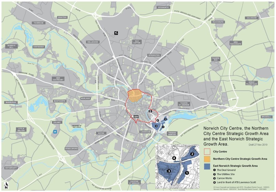
Elsewhere in the urban area, including the fringe parishes
- Reflecting the settlement hierarchy set out in policy 1, development elsewhere in the urban area and in the fringe parishes within Broadland and South Norfolk areas will support sustainable housing and employment growth on sites with good access to services.
- The area contains substantial communities located in residential areas with the benefits of being accessible to the services, facilities and employment that are located here and in the city centre. It also has the advantage of being located near to the countryside which adds to its attraction. This proximity makes the area attractive both as a place to live and for the location of employment.
- The importance of this area to the strategy for Greater Norwich is illustrated by the fact that it will provide almost half of the housing growth and the majority of the strategic employment areas.
- Housing growth in the area will consist of limited numbers of brownfield developments in existing built up areas, along with significant growth in both strategic and smaller scale extensions to the urban area.
- As set out in policy 6, strategic employment growth will be in accessible locations at Norwich Research Park, Easton/Honingham, Longwater and the Growth Triangle. Growth at these employment locations will provide sites for both knowledge intensive industries, particularly on existing and newly allocated sites at Norwich Research Park, and for building a broad-based economy.
- Further growth is planned at UEA through intensification of uses within the campus and its limited expansion. This is in line with evidence supporting growth as part of wider expansion of the education sector and of Norwich Research Park, both of which are key to economic growth in Greater Norwich.
- In line with its adopted Area Action Plan, and with the addition of a site for over 1,200 new homes at White House Farm in Sprowston allocated through this plan, the Growth Triangle provides for almost 13,000 new homes to 2038, along with the growth strategic employment areas close to Norwich Airport, at Rackheth and in Thorpe St. Andrew.
- Other strategic housing growth locations of over 1,000 homes will provide well located new communities in the west of the area. These consist of new and expanded communities in Cringleford, Easton and Hellesdon and the completion of the long-term urban extension at Three Score, Bowthorpe.
- This and other policies in the development plan ensure that such growth will be positive, adding to the choices in terms of location and quality in the area in an appropriate manner. In particular, major development should be integrated with existing communities both physically, through connecting roads, footways, cycleways and green infrastructure, and socially for example through recreational provision on new developments or improvements to existing provision.
POLICY 7.1 – The Norwich Urban Area including the fringe parishes
Norwich and the fringe parishes[98] will be the area's major focus for jobs, homes and service development to enhance its regional centre role and to promote major regeneration, the growth of strategic and smaller scale extensions and redevelopment to support neighbourhood renewal. The area will provide 30,500 additional homes and sites for a significant increase in jobs, including around 257 hectares of undeveloped land allocated for employment use.
To achieve this, development sites will be focussed in the city centre, in strategic regeneration areas in East Norwich and the Northern City Centre and at strategic urban extensions[99] in the north-east and west as well as other locations across the urban area as follows:
Housing
|
Part of Norwich Urban area |
Existing deliverable commitment (including uplift + delivery 2018/19) |
New allocations |
Total deliverable housing commitment 2018 - 2038 |
|
City centre |
|||
|
Northern City Centre Strategic Regeneration Area |
1,891 |
50 |
1,941 |
|
Other city centre sites |
2,729 |
130 |
2,859 |
|
City centre total |
4,620 |
180 |
4,800 |
|
East Norwich |
|||
|
East Norwich Strategic Regeneration Area |
780 |
1,220 |
2,000 |
|
Elsewhere in the urban area (* denotes strategic urban extensions) |
|||
|
Colney |
4 |
0 |
4 |
|
Costessey[100] |
520 |
0 |
520 |
|
Cringleford* |
1,721 |
0 |
1,721 |
|
Drayton |
318 |
0 |
318 |
|
Easton* |
1,045 |
0 |
1,045 |
|
Hellesdon* |
1,330 |
0 |
1,330 |
|
Other sites in Norwich |
2,143 |
180 |
2,323 |
|
Three Score, Bowthorpe* |
900 |
0 |
900 |
|
Taverham* |
114 |
1,400 |
1,514
|
|
The Growth Triangle* |
12,019 |
1,415 |
13,434 |
|
Thorpe St. Andrew |
354 |
0 |
354 |
|
Trowse |
244 |
0 |
244 |
|
Other sites in urban area (Old Catton, Keswick, Sprowston) |
53 |
0 |
53 |
|
Elsewhere in urban area total |
20,765 |
2,995 |
23,760 |
|
Norwich Urban Area Total |
26,165 |
4,395
|
30,560 |
Employment
|
Part of Norwich Urban Area |
Existing undeveloped employment allocations (hectares, April 2018) |
New allocations (hectares) |
Total undeveloped employment allocations (hectares) |
|
See policies 1 and 6 for the strategic sites in the Norwich Urban Area |
187.9 |
46.9 |
245.8 |
|
Hellesdon |
1.4 |
0 |
1.4 |
|
Taverham |
5.6 |
0 |
5.6 |
|
Harford Bridge |
4 |
0 |
4 |
|
Norwich urban area total |
198.9 |
46.9 |
256.8 |
Other small-scale housing and employment development will be acceptable in principle elsewhere in the Norwich urban area subject to meeting other policies in the development plan.
The City Centre
Norwich city centre's strategic role as key driver for the Greater Norwich economy will be strengthened. Development in the city centre will provide a high density mix of employment, housing, leisure and other uses. Intensification of uses within the city centre to strengthen its role as a main regional employment, retail, cultural and visitor centre, providing a vibrant and diverse experience for all, will be supported.
Comprehensive redevelopment of the large district centre at Anglia Square and surrounding vacant land will provide a viable, high density, housing-led mixed-use development including retailing, employment, community and leisure facilities. The redevelopment of Anglia Square will be the catalyst for change in the wider Northern City Centre strategic regeneration area identified on the Key Diagram and defined in map 9.
- Economy
To ensure a strong employment base, development should provide a range of floorspace, land and premises as part of mixed-use developments. Development should promote more intensive use of land to meet identified needs for start-up and grow-on space for small and medium sized enterprises including the digital creative industries, technology, financial and cultural and leisure services clusters. To support this, loss of existing office floorspace will be resisted.
Development of buildings for further and higher education, training and lifelong learning will be supported in the city centre. The development of purpose-built student accommodation will be accepted where it accords with the criteria in policy 5.
- Retail and main town centre uses
The centre's retail function will be supported as part of a complementary range of uses. Provision for any additional comparison retail floorspace will primarily be met through the intensification of retail use on existing sites.
Proposals for new development and change of use in primary and secondary retail areas and large district centres (as defined in policy 6) will be accepted where they:
- contribute to meeting identified needs for new retail floorspace and other main town centre uses, including speciality and independent shopping and small-scale retailing; or
- promote diversification of services and facilities to ensure that vitality and vibrancy can be maintained throughout the day and evening; or
- provide mixed-use development including housing, high quality employment, flexible working, education, leisure, culture and entertainment, where this supports and complements the function of the centre; or
- secure the beneficial redevelopment and adaptation of disused and underused land and premises including redundant retail floorspace.
- Leisure, culture and entertainment and the visitor economy
The city centre's leisure cultural and entertainment offer will be supported and expanded. Development of new leisure and cultural facilities, hotels and other visitor accommodation to strengthen the city centre's role as a visitor and cultural destination will be accepted in accessible locations well related to centres of activity and transport hubs. Leisure uses, including uses supporting the evening and late-night economy, will be accepted in all areas of the centre where noise and disturbance issues can be mitigated.
- Housing
To maximise the potential of the city centre to deliver new homes, housing will be required on the specific allocated sites detailed in the Sites document.
- The Natural and Built Environment
The protect and enhance the distinctive natural and built environment and heritage assets of the city centre:
- New development proposals should address the principles set out in the City Centre Conservation Area Appraisal (or any successor), providing innovative and sustainable design;
- Riverside development should provide a riverside walk and assist in delivering the priorities of the River Wensum Strategy (or any successor);
- New landmark buildings at the gateways to the city centre will be accepted where they are of exceptional quality and help to define or emphasise the significance of the gateway.
- Access and Transportation
Development will be required to contribute to measures promoted by Transport for Norwich to improve accessibility, connectivity, legibility and permeability within the city centre.
East Norwich
Development of sites allocated in the East Norwich strategic regeneration area identified on the Key Diagram and defined on map 8 including Carrow Works, the Deal Ground and the Utilities Site will contribute to the comprehensive long-term development of an innovative, high density, sustainable, mixed-use gateway quarter. This will provide a minimum of 2,000 additional homes in the plan period. East Norwich also has the potential to act as a long-term catalyst for regeneration of the wider area, potentially including the following sites if they become available:
- Redevelopment of land adjoining the railway between the Deal Ground and Carrow Works as part of the wider East Norwich strategic growth area masterplan supplementary planning document;
- Land east of Norwich City F.C.;
- Intensification of uses at Riverside and
- Regeneration in the Rouen Road area.
Site proposals within the East Norwich strategic regeneration area will meet the requirements of an area-wide masterplan to ensure co-ordinated development. This will include:
- creating a distinct, sustainable mixed-use community and new gateway quarter for the city, built at high densities, taking account of its setting adjacent to the Broads;
- the provision of area-wide infrastructure and services, including retained employment opportunities, a new local centre, and a new primary school should need be established;
- establishing an integrated access and transportation strategy which emphasises sustainable accessibility and traffic restraint, and allows for connectivity and permeability within and between the sites in the strategic regeneration area and beyond, including north-south links between Trowse and Bracondale and the north bank of the Wensum and Thorpe Road / Yarmouth Road, and east-west between the city centre and Whitlingham Country Park and the Broads including an extended riverside walk on the north and south banks of the Wensum. Proposals should be designed for ease of access to, and by, public transport, with appropriate bridge provision to ensure the sites are fully permeable by sustainable transport modes;
- planning development effectively to manage and mitigate the impact of vehicular traffic from the site/s on the local highway network including the Martineau Lane roundabout, Bracondale and King Street;
- protecting and enhancing green infrastructure assets, corridors and open spaces within the area, including enhancing linkages from the city centre to the Broads, the wider rural area and elsewhere in Norwich, to include pedestrian/cycle links between Whitlingham Country Park and the city centre;
- providing for sustainable energy generation, including a local energy network serving the area as a whole;
- protecting and enhancing heritage assets, Carrow Abbey, Carrow House, Trowse Pumping Station, Thorpe Hall and their settings, and the Bracondale , Thorpe Ridge, Trowse and Thorpe St Andrew Conservation Areas;
- achieving high quality, locally distinctive, energy efficient and flood resilient design which addresses identified risks from river and surface water flooding and mitigates against potential sources of noise and air pollution and establishes strong built frontages along the River Wensum and the defining network of streets and spaces with the sites;
- addressing and remediating site contamination; and
- planning to allow scope for greater use of the Rivers Wensum and Yare for water-based recreation, leisure and tourism including the potential inclusion of marinas and riverside moorings and access for waterborne freight subject to not impeding navigation of either river.
Elsewhere in the urban area including the fringe parishes
The remainder of the urban area including the fringe parishes will provide for a significant proportion of the total growth in Greater Norwich. Development will provide a range of sites for different types of housing, employment and community uses that are accessible and integrate well with the existing communities. It will provide necessary infrastructure, with a focus on public transport, walking and cycling, as well as social and green infrastructure.
Growth will include:
- Development of strategic and smaller scale urban extensions at existing locations committed for housing and employment uses as set out in the tables above (including that within the adopted Old Catton, Sprowston, Rackheath and Thorpe St Andrew Growth Triangle Area Action Plan), with uplift on existing allocated sites in Cringleford, Easton and Three Score (Bowthorpe);
- Significant new development proposals (including the expansion of the Norwich Research Park, and a large new allocation for homes in the Growth Triangle in Sprowston);
- Development at the University of East Anglia to cater for up to 5,000 additional students by 2038 through intensification of uses within the campus and its limited expansion;
- Development sites in the Sites document which will support neighbourhood-based renewal on brownfield sites, with densities highest in the most accessible locations and
- Enhancements to the green infrastructure network which will include links to and within the Wensum, Yare, Tud and Tas Valleys, Marriott's Way and from Mousehold through the north-east growth triangle as set out in map 8, along with local networks.
In addition, a large contingency site is identified in Costessey to be brought forward if delivery of housing in the GNLP area does not meet local plan targets.
Alternative approaches
The Norwich urban area policy covers a wide range of issues.
The policy for the City centre tries to promote and balance a wide range of potentially competing uses. Although all these uses need to be accommodated, there could be several alternative approaches or different emphases to achieve this.
The policy allows for evening and late-night leisure uses across the city centre. An alternative would be to retain the current approach of focussing such uses in specific areas of the city centre.
The policy identifies a large contingency site at Costessey. If clear evidence for delivery is submitted, an alternative approach would be to allocate the site (increasing the overall level of residential allocations in the plan).
Consultation Questions for Policy 7.1 – The Norwich Urban area including the fringe parishes
- (18) Do you support or object or wish to comment on the approach for the city centre? Please identify particular issues.
- (17) Do you support or object or wish to comment on the approach for East Norwich? Please identify particular issues.
- (41) Do you support or object or wish to comment on the approach for elsewhere in the urban area including the fringe parishes? Please identify particular issues.
Policy 7.2 The Main Towns
- In line with the settlement hierarchy, the main towns of Aylsham, Diss (with part of Roydon), Harleston, Long Stratton and Wymondham collectively provide 6,342 homes, around 14% of the proposed housing growth planned to 2038.
- The towns play a vital role in the rural economy, providing employment opportunities and services for wider hinterlands. As such, they are engines of rural growth and it is important that they are enabled to grow at appropriate scales, having regard to infrastructure and environmental issues, to enable them to thrive. Growth in these towns will have good access to services.
- Some development is already identified for the towns through existing local plans. In particular, major development proposals are set out in the Long Stratton and Wymondham Area Action Plans (AAPs), which are not superseded by the GNLP and continue to operate.
- Since allocations meet growth needs, in line with other policies in this plan, windfall sites will be limited to locations within and, for very small developments limited to 3 homes, adjacent to settlement boundaries.
- Retail evidence[101] suggests that there will not be the need for major additional retail expansion in the main towns, with the possible exception of Diss. Since retailing is experiencing significant changes, no land allocations are made through the plan. This policy and policy 6 allow for such development, prioritising town centre locations, if new evidence justifies it.
Aylsham
- Aylsham has a good range of shops and services in and around its attractive and historic centre and local employment opportunities. Transport links to and from the town via the A140 are good, including regular bus services to Norwich and North Norfolk. Delivery of housing has been good in recent years and just over 200 homes remain to be delivered from 2018 commitments.
- The Bure Valley and the Marriott's Way form the core of a well-developed local and strategic green infrastructure network and development could support further improvements.
- To support the continued vitality of Aylsham and to locate an appropriate amount of growth in this main town, 300 additional homes are allocated on a site to the south-east of the town centre through the GNLP. The site has good access to the A140 and public transport. A new primary school required to serve growth in the town is included in the allocation. Anglian Water plans to increase capacity at the local water recycling centres at Aylsham and Belaugh to serve growth.
Diss (with part of Roydon adjacent to Diss)
- Diss is strategically located on the Norwich to London railway line and the A140 and A143 provide road links to Norwich, Ipswich, east coast ports and Bury St. Edmunds. Diss is also a hub for local bus links.
- Diss has the widest range of shops and services of the main towns, as well as a broad range of employment opportunities mainly located to the east of the town centre close to the railway. The shops and services are mainly within the attractive town centre of Diss, which has significant pedestrian priority areas, along with supermarkets on Victoria Road. Diss Mere and its surrounding green space provide a distinctive focal point for the town centre.
- These locational attributes and connectivity provide the potential for economic growth as an enhanced centre serving a large rural hinterland in South Norfolk and northern Suffolk.
- Diss and Roydon are in the Waveney Valley. The valley provides an attractive setting for the settlements and is the hub of an extensive green infrastructure network including the Angles and Boudicca Ways.
- While delivery of housing has been good in recent years, associated environmental constraints place limits on the potential for housing expansion. Local evidence[102] shows that traffic constraints, particularly on Victoria Road, also reduce the potential for significant additional expansion.
- The existing commitment of just over 300 dwellings in April 2018 is complemented by a brownfield site neighbouring the railway station, which offers the potential for medium to high density development, along with a greenfield allocation to the north of the town. The latter provides for a short link road between radial routes. Together, these sites provide 400 additional homes, so a total increase of just over 700 homes is planned to 2038.
- Evidence[103] suggests that Diss has the best potential of the main towns for retail growth, which could be accompanied by further improvements to the public realm and a strengthened food and beverage offer in the town centre.
- The GVA Study also shows that Diss has the potential for jobs growth on existing undeveloped allocated employment land, particularly for manufacturing, including high value activities. The sites are close to the railway line and have good access to a large neighbouring employment area at Eye Airfield, allowing for complementary activities.
Harleston
- Harleston has a smaller range of more specialist retail facilities and services which provide for a more local catchment in South Norfolk and northern Suffolk. These have the potential for expansion. It has good road links to the east and west via the A143 and access to Norwich via the A140 will be improved by delivery of the Long Stratton by-pass. A local bus network is focussed on the town.
- Harleston is close to the River Waveney and the Angles Way along the valley forms part of the strategic green infrastructure network.
- Housing delivery has been good in Harleston in recent years. The plan allocates two sites to the south-east of the town centre within the A143 by-pass and close to employment areas. The sites provide for 450 new homes and significant areas of open space in addition to the April 2018 commitment of around 170 dwellings. Growth of just over 600 new homes in Harleston to 2038 will support the retention and expansion of services and jobs in this attractive market town.
Long Stratton
- Due to the scale of the existing commitment in Long Stratton, which will both provide a by-pass and the growth of services supporting its classification as a main town, this plan does not make further allocations in addition to Long Stratton's Area Action Plan (AAP). Evidence[104] shows that the scale of the commitment means that parts of the site allocated in the AAP will not be delivered until after 2038. There may be further potential capacity for development within the existing allocation, beyond the 1,875 homes that are the subject of current planning applications; however, these would be unlikely to be delivered until late in the plan period, or beyond.
- The AAP identifies some infrastructure capacity constraints, particularly in relation to Long Stratton Water Recycling Centre, although Anglian Water plans to increase capacity to serve growth. The GNLP is not intended to replace the AAP, which may therefore be reviewed separately later to address the delivery of additional housing in Long Stratton, if required.
Wymondham
- The plan allocates two sites in Wymondham for a total of 100 additional dwellings to 2038. With the major housing commitment and employment expansion set out in Wymondham's Area Action Plan, this means that the town will grow by around 2,600 homes, along with strategic employment growth at Browick Road. This will both support Wymondham's role as a main town serving the south-west of Greater Norwich and contribute to the development of the Cambridge Norwich Tech Corridor.
- Due to its strategic location, the settlement of Wymondham is also identified for a contingency of 1,000 additional dwellings to be brought forward if delivery of housing in the GNLP area does not meet local plan targets.
Note: At this Regulation 18 stage, no specific site in Wymondham has been identified to provide this contingency housing allowance.
- Anglian Water plans to increase capacity at the local water recycling centre at Wymondham to serve growth.
- The strategic gaps identified through this plan and other policies in the development plan aim to prevent coalescence of Wymondham and Hethersett.
POLICY 7.2 – THE MAIN TOWNS
The Main Towns of Aylsham, Diss (with part of Roydon), Harleston, Long Stratton and Wymondham will continue to be developed to enhance their function as attractive places to live and providers of employment and services to serve the towns and their hinterlands, with substantial levels of development expected to take place. This will provide for around 6,300 additional homes and sites for employment and commercial land and related infrastructure.
The identified levels of development, including growth committed in the Long Stratton and Wymondham Area Action Plans, are:
Housing
|
Main Town |
Existing deliverable commitment (including uplift + delivery 2018/19) |
New allocations |
Total deliverable housing commitment 2018 - 2038 |
|
Aylsham |
221 |
300 |
521 |
|
Diss (with part of Roydon) |
343 |
400 |
743 |
|
Harleston |
173 |
450 |
623 |
|
Long Stratton |
1,892 |
0 |
1,892 |
|
Wymondham[105] |
2,463 |
100 |
2,563 |
|
Total |
5,092 |
1,250 |
6,342 |
Other residential development will be acceptable elsewhere within settlement boundaries subject to meeting the criteria of other policies in the development plan.
Employment
|
Main Town |
Existing undeveloped employment allocations (hectares, April 2018) |
New employment allocations (hectares) |
Total employment allocations (hectares)
|
|
See polices 1 and 6 for the strategic site in Wymondham |
22 |
0 |
22 |
|
Aylsham |
4 |
0 |
4 |
|
Diss (with part of Roydon) |
10.8 |
0 |
10.8 |
|
Harleston |
6.8 |
0 |
6.8 |
|
Long Stratton |
12.5 |
0 |
12.5 |
|
Wymondham |
2.1 |
0 |
2.1 |
|
Total |
58.2 |
0 |
58.2 |
Other small-scale employment development will be acceptable in principle elsewhere in the towns subject to meeting other policies in the development plan.
Retail and other town centre type uses should be located in or adjoining the town centres. Proposals which support speciality and independent shopping, small-scale retailing and diversification of services and facilities will be encouraged.
Enhancements to the multi-functional green infrastructure network will be provided by development to contribute to the strategic network as set out in map 8 and to linking local networks.
Alternative approaches
The main towns of Aylsham, Diss (with part of Roydon), Harleston, Long Stratton and Wymondham are drivers of the rural economy and it is important they can grow at appropriate scales. The plan identifies sites for approximately 14% of new housing in main towns.
Much of the proposed development has planning permission. The approach being taken recognises the already significant commitments in main towns, especially in Long Stratton and Wymondham. More capacity for new allocations is available in Aylsham, Diss (with part of Roydon), Harleston and Wymondham.
The 14% proportion of new housing could be increased as a large number of reasonable alternative sites have been proposed in the main towns.
However, overall the preferred option is considered to provide a suitable amount of growth in relation to the settlement hierarchy, infrastructure and local constraints.
The Sites document sets out the preferred option and reasonable alternative sites.
Consultation Questions for Policy 7.2 – The Main Towns
- (23) Do you support or object or wish to comment on the approach for the main towns overall? Please identify particular issues.
- (37) Do you support or object or wish to comment on the approach for specific towns (Aylsham, Diss (with part of Roydon), Harleston, Long Stratton and Wymondham)? Please identify particular issues.
Policy 7.3 The Key Service Centres
- The Key Service Centres of Acle, Blofield, Brundall, Hethersett, Hingham, Loddon / Chedgrave, Poringland / Framingham Earl, Reepham and Wroxhamprovide 3,417 homes, around 8% of the proposed housing growth. This reflects the settlement hierarchy and is made up of significant existing commitments, with additional sites allocated through this plan in the locations with the best opportunities for further growth and the fewest constraints.
- The Key Service Centres have a relatively good range of services, access to public transport and employment opportunities and play a vital role in serving the rural areas. This role is intended to continue with development taking place at appropriate levels.
- High amounts of existing commitments and environmental and infrastructure constraints limit the potential for additional housing growth through this plan at Blofield, Brundall, Poringland / Framingham Earl and Reepham. Traffic constraints and proximity to the Broads at Wroxham restrict growth.
- The focus of additional housing growth identified through this plan is therefore at Acle, Hethersett, Hingham and Loddon / Chedgrave.
- Acle has been identified for additional growth on well-located sites which could provide a link road to the west of the village. The village has a good range of services including a secondary school. It also has good bus and rail services and is strategically located between Norwich and Great Yarmouth to benefit from employment growth, including in the offshore energy sector.
- Hethersett is close to Norwich and within the Cambridge Norwich Tech Corridor. It has a range of services including a secondary school and good access to other services, with good public transport links to Norwich and Wymondham. It also has good access to employment opportunities at a range of strategic and more local sites. As a result, major development is committed to the north and west of the village and additional growth identified through this plan will be delivered through uplift within the existing allocation. Strategic gaps identified through this plan and detailed in development management policies between Wymondham and Hethersett and Hethersett and Cringleford aim to prevent the settlements joining up.
- Hingham has limited existing commitment, a range of services and employment, good public transport links and is well located to benefit from additional employment opportunities in the Cambridge Norwich Tech Corridor. The two additional allocations to the east and west of the village, which provide for 100 homes, both have good access to services and public transport.
- Loddon / Chedgrave has a good range of services, good public transport links and is well located between Norwich and Lowestoft to benefit from employment growth, including in the offshore energy sector. Additional growth is allocated on a small site to the north of Chedgrave and a larger site to the south-east of Loddon.
- In line with other policies in this plan, windfall sites will be limited to locations within and, for very small developments limited to 3 homes, adjacent to settlement boundaries.
POLICY 7.3 – THE KEY SERVICE CENTRES
The Key Service Centres of Acle, Blofield, Brundall, Hethersett, Hingham, Loddon / Chedgrave, Poringland / Framingham Earl, Reepham and Wroxham will continue to be developed to enhance their function as places to live and providers of employment and services to serve the settlement and its hinterland,with significant levels of development expected to take place in the majority of centres. This will provide for a minimum of 3,253 additional homes and sites for 11.79 hectares of employment / commercial land and related infrastructure.
The main areas for development are:
Housing
|
Key Service Centre |
Existing deliverable commitment (including uplift + delivery 2018/19) |
New allocations |
Total deliverable housing commitment 2018 - 2038 |
|
Acle |
191 |
200 |
391 |
|
Blofield |
338 |
15 |
353 |
|
Brundall |
175 |
0 |
175 |
|
Hethersett |
1,369 |
0 |
1,369 |
|
Hingham |
16 |
100 |
116 |
|
Loddon / Chedgrave |
200 |
200 |
400 |
|
Poringland / Framingham Earl |
467 |
0 |
467 |
|
Reepham |
142 |
0 |
142 |
|
Wroxham |
4 |
0 |
4 |
|
Total |
2,902 |
515 |
3,417 |
The sites to meet the above targets are in the GNLP Sites document.
Other residential development will be acceptable elsewhere within settlement boundaries subject to meeting the criteria of other policies in the development plan.
Employment
|
Key Service Centre |
Existing undeveloped employment allocations (hectares, April 2018) |
New allocations (hectares) |
Total employment allocations (hectares)
|
|
Acle |
0.7 |
0 |
0.7 |
|
Hingham |
2.2 |
0 |
2.2 |
|
Loddon / Chedgrave |
1.8 |
0 |
1.8 |
|
Poringland / Framingham Earl |
4.3 |
0 |
4.3 |
|
Reepham |
2.8 |
0 |
2.8 |
|
Total |
11.8 |
0 |
11.8 |
Other small-scale employment development will be acceptable in principle elsewhere in the key service centres subject to meeting other policies in the development plan.
Enhancements to the multi-functional green infrastructure network will be provided by development to contribute to the strategic network as set out in map 8 and to linking local networks.
Alternative approaches
This plan proposes allocations for sites for approximately 8% of new housing in key service centres. Much of that is in existing commitments 2,902 homes, with new allocations totalling 515 homes proposed. This approach recognises that while some key service centres have large existing commitments, along with environment and infrastructure constraints, capacity for new development exists in several key service centres.
The 8% proportion of new housing in key service centres could be increased as many reasonable alternative sites have been proposed in key service centres. However, overall the preferred option is considered to provide a suitable amount of growth in relation to the settlement hierarchy, infrastructure and local constraints. The Sites document sets out the preferred option and reasonable alternative sites.
Consultation Questions for Policy 7.3 – The Key Service Centres
- (19) Do you support or object or wish to comment on the approach for the key service centres overall? Please identify particular issues.
- (29) Do you support or object or wish to comment on the approach for specific key service centres: (Acle, Blofield, Brundall, Hethersett, Hingham, Loddon / Chedgrave, Poringland / Framingham Earl, Reepham, Wroxham)? Please identify particular issues.
Policy 7.4 Village clusters
- The remaining permitted and allocated housing growth, 4,024 homes, around 9% of the total for Greater Norwich in the plan period, is on sites in village clusters. Village clusters are based on primary school catchments, which provide a proxy for social sustainability.
- Locating this level of growth in village clusters aims to promote social sustainability by supporting rural life and services. The provision of several relatively small allocation sites as required by the National Planning Policy Framework means this approach also has the benefit of supporting small-scale builders, providing choice for the market and helping to ensure the delivery of housing in popular village locations. The policy also aims to provide a range of sizes and tenures of new homes to meet needs in village clusters.
- A separate South Norfolk Village Clusters Housing Site Allocations document will be produced. This plan will include sites for a minimum of 1,200 homes in addition to the 1,349 already committed in the village clusters to be identified in South Norfolk.
- The village clusters in Broadland and the indicative amount of growth planned for each cluster are set out in appendix 5 of this strategy. The GNLP Sites Plan allocates sites to meet the strategic requirement for up to 480 more homes in addition to the 995 homes already committed in the village clusters in Broadland.
- The village clusters cover the remaining areas of Broadland outside the Norwich fringe, main towns and key service centres. Some smaller settlements are clustered with towns and villages higher in the settlement hierarchy, such as the villages around Aylsham. This applies where the larger settlement provides the local primary school.
- The scale of growth in any cluster in Broadland as shown appendix 5 reflects school capacity or ability to grow and the availability of other accessible services, the "social capacity" of a cluster. The identification of sites with the fewest constraints has also helped to provide the indicative view on the potential amount of growth in specific clusters.
- To reduce additional car journeys and encourage healthy and active lifestyles, new housing allocations have been preferred on sites within village clusters with good access to a primary school and a safe route to school.
- Policies 1 and 7.4 also support windfall development for affordable housing in the village clusters in both Broadland and South Norfolk, with some market housing permitted where it supports viability, including self/custom-build. The policies allow for infill and small extensions in those parts of village clusters which have a settlement boundary.
- This approach will provide for appropriate levels of growth in accessible locations in village clusters as required by policy 1.
POLICY 7.4 – VILLAGE CLUSTERS
Housing
To provide a minimum of 4,024 homes as set out in policy 1 and to support village services, provide choice for the market and promote delivery of a variety of housing types and tenures, housing development will be supported in principle on a range of sites within the village clusters.
To achieve this:
- New sites in village clusters to provide a minimum of 1,200 homes will be allocated through a South Norfolk village clusters plan;
- New sites in village clusters in Broadland to provide up to 480 homes are allocated in the Greater Norwich Local Plan Sites Plan.
Note: New sites submitted through this consultation will be considered for allocation in this plan or in the South Norfolk Village Clusters Housing Site Allocations document. Sites of between half a hectare and 1 hectare are particularly welcomed (see questions below).
Additional sites may be provided in village clusters by:
- Infill development within settlement boundaries;
- Affordable housing led development, which may include an element of market housing (including self/custom build) if necessary, for viability, up to a maximum of 15 dwellings in total. These sites should be adjacent or well related to settlement boundaries with good access to services, including safe routes to schools, subject to other policies of the local plan.
The cumulative amount of windfall development permitted during the plan period should not have a negative impact on the character and scale of settlements in any village cluster.
Employment
The allocated Employment Areas are:
|
Location |
Existing undeveloped employment allocations (hectares, April 2018) |
New allocations (hectares) |
Total employment allocations (hectares) |
|
See policies 1 and 6 for the strategic site at Hethel |
20 |
0.8 |
20.8 |
|
Brooke |
4.8 |
0 |
4.8 |
|
Foulsham |
1.1 |
0 |
1.1 |
|
Lenwade |
2.4 |
0 |
2.4 |
|
Lingwood |
2.3 |
0 |
2.3 |
|
Total |
30.6 |
0.8 |
31.4 |
Other small-scale employment development will be acceptable in principle elsewhere within village development boundaries or through the re-use of rural buildings subject to meeting other policies in the development plan.
Enhancements to the multi-functional green infrastructure network provided by development will contribute to the strategic network as set out in map 8 and to linking local networks.
Alternative approaches
In total, the proposed allocations coupled with the existing commitment provides sites for approximately 9% of new housing to be in village clusters across Greater Norwich. In addition, Policy 7.4 also allows for affordable housing-led windfall development in Broadland. Policy 7.5 allows for additional small-scale windfall development in all parishes across Greater Norwich.
Overall, the proposed approach is considered to provide a suitable amount of growth taking account of the settlement hierarchy and local constraints. It achieves the aim of providing a suitable level of growth in village clusters to help rural communities thrive while taking account of basic planning criteria and issues such as the capacity in the local school and promoting active lifestyles through safe routes to school.
Alternative approaches might seek more or less development or a different distribution within the villages. However, the scope for more growth or a different distribution is limited without breaching normal planning criteria and the sustainable site selection process. The majority of acceptable sites have been allocated and all the sites that have been identified as reasonable alternatives are in those clusters with preferred options. The alternative of a significantly lower level of growth would undermine the contribution that development can make to the social sustainability of village clusters.
Consultation Questions for Policy 7.4 – The Village Clusters
- (51) Do you support or object or wish to comment on the overall approach for the village clusters? Please identify particular issues.
- (64) Do you support or object or wish to comment on the approach for specific village clusters?
Please identify particular issues.
Please submit any additional sites in village clusters in either Broadland or South Norfolk which you feel are suitable for allocation. We are particularly looking for sites of less than 1 hectare which could provide a minimum of 12 homes.
Policy 7.5 Small Scale Windfall Housing Development
- This policy applies to all parishes. Its purpose is to allow for a limited number of additional dwellings in each parish beyond those allocated or allowed for as larger scale windfall sites through policies other policies in this plan. The policy limits the number of homes on small scale windfall sites to three to prevent over development in rural areas. Policy 7.5 promotes small scale housing development, including self/custom build. This complements policies 5 and 7.4 which also support self/custom build.
- To achieve this, the policy provides limited additional opportunities for the development of homes:
- adjacent to settlements with development boundaries
- or on infill sites within a recognisable group of dwellings which do not have a development boundary.
The policy also requires such developments to respect character of the settlement and landscape.
- Additional requirements applying to all sites such as providing safe highways access set in policy 2 will be applied to these sites, though with greater flexibility in relation to access to services due to the very limited scale of development supported by the policy.
POLICY 7.5 – SMALL SCALE WINDFALL HOUSING DEVELOPMENT
Development of up to a maximum total of 3 dwellings within each parish during the lifetime of the plan will, in principle, be permitted on sites adjacent to a development boundary or on infill sites within a recognisable group of dwellings. Self/custom build will be supported. Proposals will respect the form and character of the settlement and have no detrimental impact on the landscape and natural environment.
Alternative approaches
The aim of policy 7.5 is to allow for a limited number of additional dwellings in each parish beyond those allocated or allowed for as larger scale windfall sites through other plan policies. An alternative could be to allow more growth on such sites, perhaps up to 5 homes, but the policy allows for sufficient additional growth to support the plan's aim tosupport thriving rural communities and offers opportunities for local housing need to be met.
Consultation Questions for Policy 7.5 – Small Scale Windfall Housing Development
- (32) Do you support or object or wish to comment on the overall approach for Small Scale Windfall Housing Development? Please identify particular issues.
[53] The 2017 Greater Norwich Employment, Retail and Town Centres Study (the GVA study)
[56] Housing Commitment is sites which are allocated or have permission for housing development
[58] Paragraph 68 a) of the NPPF requires plans to identify land to accommodate at least 10% of the housing requirement on sites of no larger than one hectare.
[59] This includes existing allocated sites carried forward, new allocations made through the GNLP and sites with planning consent.
[60] The Norwich fringe is the built up parts of the fringe parishes of Colney, Costessey, Cringleford, Drayton, Easton, Hellesdon, Old Catton, Sprowston, Taverham, Thorpe St. Andrew, Trowse and the remainder of the Growth Triangle.
[61] This figure is based on the higher potential Broadland village cluster site capacities set out in appendix 5 and the GNLP Sites Plan
[62] This will be confirmed through the housing delivery trajactories in the publication (Regulation 19) version of the plan. As part of this draft plan (Regulation 18) consultation, we have written to all of the site owners/agents for the preferred options and reasonable alternative housing sites. This is to require the site owners/agents to evidence that their sites will deliver in either the 0-5, 6-10 or final period of the plan to enable sites to be included in the publication version of the plan. Trajectories will be included in the publication version based on the feedback and for each site.
[63] Addressed through policy 1 of this plan.
[65] Estimated by the Government at £6-9 per dwelling (The Housing Standards Review, 2014)
[66] The Greater Norwich Energy Infrastructure Study (March 2019)
[67] New Anglia Local Enterprise Partnership's Norfolk and Suffolk Economic Strategy
[68] GNLP Viability Assessment (NPS, September 2019)
[69] Major developments are 10 dwellings or more, 1,000 square metres of floor space or 1 hectare or more of land.
[70] The Government approved Building for Life 12 standard for well-designed homes is available here.
[72] The indicative densities are inter-related with local design issues (see policy 3). Higher densities are encouraged in and close to defined district and town centres, and in particular in the city centre.
[73] Health Impact Assessments are required for allocated sites of 500 dwellings plus, for non-allocated housing sites of 100 dwellings plus and for any housing proposal with a significant amount of housing for the elderly to show how the health care infrastructure needs of the new development are provided for.
[74] Interim Habitats Regulations Assessment of Greater Norwich Local Plan Issues and Options stage, The Landscape Partnership, 2017
[75] Additional opportunities for the establishment of country parks to provide mitigation, such as at Houghen Plantation in Horsford, will also be progressed so that specific proposals are included in the Regulation 19 version of this plan.
[76] The GNLPIR covers: transport; utilities; education; health care; police; fire and rescue; community facilities (libraries and community centres); sport and leisure facilities; green infrastructure and waste management.
[84] Clarification dependent on Water Cycle Study
[85] Local housing evidence is in the Strategic Housing Market Assessment (2017) and in the Greater Norwich Viability Study (2019).
[86] Evidenced through the Greater Norwich Local Plan Nationally Described Space Standards Study (August 2019) within the Viability Study
[88] Extra care housing is a self-contained residential accommodation (where units are rented or owned by the individual or couples who occupy them) with communal facilities designed to meet the needs and aspirations of older people and have care staff on site 24/7.
[89] Living Well – Homes for Norfolk (2018)
[90] Norfolk Caravans and Houseboats Accommodation Needs Assessment (ANA) including for Gypsies, Travellers and Travelling Show people October 2017
[92] 10 dwellings or more
[93] Evidenced through the Greater Norwich Local Plan Nationally Described Space Standards Study (August 2019) within the Viability Study
[95] Source: Greater Norwich annual monitoring reports
[96] The Norwich fringe is the built-up parts of the fringe parishes of Colney, Costessey, Cringleford, Drayton, Easton, Hellesdon, Old Catton, Sprowston, Taverham, Thorpe St. Andrew, Trowse and the remainder of the Growth Triangle
[97] Norwich City Centre Future Retail Strategy,The Retail Group on behalf of Norwich BID, June 2019
[98] The Norwich fringe is the built-up parts of the fringe parishes of Colney, Costessey, Cringleford, Drayton, Easton, Hellesdon, Old Catton, Sprowston, Taverham, Thorpe St. Andrew, Trowse and the remainder of the Growth Triangle
[99] Strategic urban extensions/strategic housing growth locations will each provide over 1,000 new homes from 2018 to 2038
[100] A 1,000-home contingency site at Costessey will be brought forward if delivery of housing in the GNLP area does not meet local plan targets. It is not included in these figures.
[101] Greater Norwich Employment, Town Centre and Retail Study (The GVA Study)
[102] In the emerging Diss Market Town Network Improvement Strategy (NIS)
[103] Greater Norwich Employment, Town Centre and Retail Study (The GVA Study)
[104] Analysis of Commitments
[105] The settlement of Wymondham is also identified as a contingency for 1,000 additional dwellings to be brought forward if delivery of housing in the GNLP area does not meet local plan targets. At this Regulation 18 stage, no specific site has been identified to provide this contingency housing allowance.